


Rougé(les pierres rouges)et Fercé

chasle
User
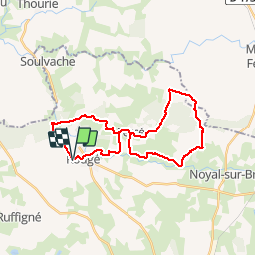

Length
27 km

Max alt
125 m

Uphill gradient
318 m
Km-Effort
31 km

Min alt
43 m

Downhill gradient
321 m
Boucle
Yes
Creation date :
2019-01-15 16:30:39.932
Updated on :
2019-01-15 16:30:39.932
7h08
Difficulty : Easy

FREE GPS app for hiking
 SityTrail
IGN / Geographical institutes
SityTrail Plus
The world is yours!
About
Trail Walking of 27 km to be discovered at Pays de la Loire, Loire-Atlantique, Rougé. This trail is proposed by chasle.
Description
Balisage jaune
Positioning
Country:
France
Region :
Pays de la Loire
Department/Province :
Loire-Atlantique
Municipality :
Rougé
Location:
Unknown
Start:(Dec)
Start:(UTM)
615721 ; 5293354 (30T) N.
Comments