Trail Walking Saint-Michel - Sentier de découverte du Terrefort - Saint-Michel - Photo

Sentier de découverte du Terrefort - Saint-Michel

 tracegps
tracegps

User

© OpenStreetMap contributors
Length
Length
5.7 km
Max alt
Max alt
407 m
Uphill gradient
Uphill gradient
124 m
Km-Effort
Km-Effort  
7.3 km
Min alt
Min alt
305 m
Downhill gradient
Downhill gradient
124 m
Boucle
Boucle
Yes
Creation date :
2014-12-10 00:00:00.0
Updated on :
2014-12-10 00:00:00.0

(3 Reviews)

Walking
Walking
1h30
Difficulty : Easy

Scan this QR Code to open this trail in the SityTrail application

FREE GPS app for hiking

Logo SityTrail SityTrail

IGN / Geographical institutes

Download SityTrail from the App Store Download SityTrail from Google Play

Logo SityTrail SityTrail World

The world is yours!

Download SityTrail from the App Store Download SityTrail from Google Play Download SityTrail on Huawei AppGallery

About

Trail Walking of 5.7 km to be discovered at Occitania, Ariège, Saint-Michel. This trail is proposed by tracegps.

Description

Circuit proposé par l’Office de Tourisme du Pays de Pamiers. Départ de l’église de saint-Michel. Retrouvez ce circuit sur le site de l’Office de Tourisme du Pays de Pamiers. Ce circuit a été numérisé par les randonneurs du CODEPEM. Merci à Jean-Marie.

Elevation profile

Photos

Positioning

Country:
France
Region :
Occitania
Department/Province :
Ariège
Municipality :
Saint-Michel
Location:
Unknown
Start:(UTM)
378181 ; 4776856 (31T) N.

Comments

Please log in to post a review or rate the element


Sympa


Très bien


Trails nearby

Trail Walking Saint-Martin-d'Oydes - St Martin d Oydes Esplas - Photo
Walking
pidjam

Walking

Easy
Saint-Martin-d'Oydes, Occitania, Ariège, France
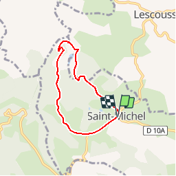
12.2 km | 16 km-effort
3h 26min
Yes
Trail Equestrian Artigat - Artigat - Durfort - Photo
Equestrian
tracegps

Equestrian

Difficult
Artigat, Occitania, Ariège, France
13.5 km | 18.1 km-effort
1h 15min
No
Trail Equestrian Escosse - Boucle du Terrefort - Escosse - Saverdun - Photo
Equestrian
tracegps

Equestrian

Medium
Escosse, Occitania, Ariège, France
19.6 km | 25 km-effort
2h 30min
No
Trail Equestrian Pailhès - Chemin de St Jacques -Pailhès - Rioutaillol - Photo
Equestrian
tracegps

Equestrian

Difficult
Pailhès, Occitania, Ariège, France
8.3 km | 12.3 km-effort
1h 0min
No
Trail Hunting Artigat - Artigat - Photo
Hunting
David Girabet

Hunting

Easy
Artigat, Occitania, Ariège, France
3.3 km | 4.5 km-effort
2h 14min
Yes
Trail Hunting Saint-Michel - St Michel Becasses - Photo
Hunting
David Girabet

Hunting

Saint-Michel, Occitania, Ariège, France
3.5 km | 4.7 km-effort
1h 53min
No
Trail Walking Saint-Victor-Rouzaud - GR78 - Etape 5bis Saint Victor Rouzaud - Caoué de coume - Photo
Walking
patoche2009

Walking

Medium
Saint-Victor-Rouzaud, Occitania, Ariège, France
37 km | 51 km-effort
10h 36min
No
Trail Walking Pailhès - Pailhes-Le Mas - Photo
Walking
DEDIEUJ

Walking

Medium
Pailhès, Occitania, Ariège, France
15.3 km | 21 km-effort
4h 30min
No
Trail Walking Artigat - Bajou Artigat fait 2022 - Photo
Walking
pidjam

Walking

Medium
Artigat, Occitania, Ariège, France
11.8 km | 0 m-effort
2h 50min
Yes


Close
My subscriptions