Trail Walking Saint-Laurent-de-Terregatte - Autour de la Roche qui Boit - Photo

Autour de la Roche qui Boit

 tracegps
tracegps

User

© OpenStreetMap contributors
Length
Length
12.4 km
Max alt
Max alt
107 m
Uphill gradient
Uphill gradient
327 m
Km-Effort
Km-Effort  
16.7 km
Min alt
Min alt
29 m
Downhill gradient
Downhill gradient
329 m
Boucle
Boucle
Yes
Creation date :
2014-12-10 00:00:00.0
Updated on :
2014-12-10 00:00:00.0

(0 Reviews)

Walking
Walking
3h30
Difficulty : Very difficult

Scan this QR Code to open this trail in the SityTrail application

FREE GPS app for hiking

Logo SityTrail SityTrail

IGN / Geographical institutes

Download SityTrail from the App Store Download SityTrail from Google Play

Logo SityTrail SityTrail World

The world is yours!

Download SityTrail from the App Store Download SityTrail from Google Play Download SityTrail on Huawei AppGallery

About

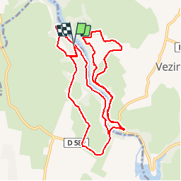
Trail Walking of 12.4 km to be discovered at Normandy, Manche, Saint-Laurent-de-Terregatte. This trail is proposed by tracegps.

Description

Très belle balade pédestre le long de la retenue d’eau de la Roche qui Boit. Sentier bordant le lac difficile voire très difficile par temps humide. Nombreux dénivelés. Randonnée dédiée aux randonneurs expérimentés et aux adeptes de Trail extrème. À déguster : L'Autre café, endroit très original au bord de l'eau avec de nombreuses expositions. à ne pas manquer!!! Location possible de GPS à l'Office de Tourisme de Ducey ou de St James et sur www.label-nature.net

Elevation profile

Positioning

Country:
France
Region :
Normandy
Department/Province :
Manche
Municipality :
Saint-Laurent-de-Terregatte
Location:
Unknown
Start:(Dec)
Start:(UTM)
629012 ; 5384247 (30U) N.

Trails nearby

Trail Walking Ducey-les-Chéris - Au fil de la Sélune - Photo
Walking
tracegps

Walking

Medium
(1)
Ducey-les-Chéris, Normandy, Manche, France
8.6 km | 9.5 km-effort
2h 0min
Yes
Trail Cycle Isigny-le-Buat - Véloscénie 4ème étape - Photo
Cycle
destras

Cycle

Easy
Isigny-le-Buat, Normandy, Manche, France
120 km | 131 km-effort
6h 50min
No
Trail Bicycle tourism Ducey-les-Chéris - Véloscénie Ducey Mont St Michel - Photo
Bicycle tourism
famiski

Bicycle tourism

Very easy
Ducey-les-Chéris, Normandy, Manche, France
33 km | 36 km-effort
2h 51min
No
Trail Mountain bike Ducey-les-Chéris - F.DuceyStMalo37H89.369.VTT0 - Photo
Mountain bike
francois58

Mountain bike

Medium
Ducey-les-Chéris, Normandy, Manche, France
89 km | 96 km-effort
6h 25min
No
Trail Walking Poilley - Courtils - Photo
Walking
Bernardroland

Walking

Very easy
Poilley, Normandy, Manche, France
14.9 km | 15.9 km-effort
3h 46min
No
Trail Walking Ducey-les-Chéris - Ducey - Photo
Walking
PatRando

Walking

Easy
(1)
Ducey-les-Chéris, Normandy, Manche, France
11.5 km | 12.6 km-effort
2h 47min
Yes
Trail Running Saint-Laurent-de-Terregatte - Autour de la Roche qui Boit - Photo
Running
tracegps

Running

Very difficult
Saint-Laurent-de-Terregatte, Normandy, Manche, France
12.4 km | 16.7 km-effort
1h 30min
Yes
Trail Cycle Ducey-les-Chéris - Le Val de l'Oir - Photo
Cycle
tracegps

Cycle

Medium
Ducey-les-Chéris, Normandy, Manche, France
28 km | 35 km-effort
2h 0min
No
Trail Cycle Ducey-les-Chéris - Du Beuvron à la Sélune - Photo
Cycle
tracegps

Cycle

Difficult
Ducey-les-Chéris, Normandy, Manche, France
25 km | 29 km-effort
1h 39min
Yes


Close
My subscriptions