


MONTBAZIN-la garrigue plane

JEANJOSY
User
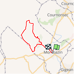

Length
11.9 km

Max alt
188 m

Uphill gradient
259 m
Km-Effort
15.3 km

Min alt
27 m

Downhill gradient
259 m
Boucle
Yes
Creation date :
2019-01-15 16:38:00.21
Updated on :
2019-04-25 09:03:49.435
3h17
Difficulty : Difficult

FREE GPS app for hiking
 SityTrail
IGN / Geographical institutes
SityTrail Plus
The world is yours!
About
Trail Walking of 11.9 km to be discovered at Occitania, Hérault, Montbazin. This trail is proposed by JEANJOSY.
Positioning
Country:
France
Region :
Occitania
Department/Province :
Hérault
Municipality :
Montbazin
Location:
Unknown
Start:(Dec)
Start:(UTM)
556063 ; 4818211 (31T) N.
Comments