


Anielle j4

ARPF
User
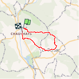

Length
10.8 km

Max alt
1228 m

Uphill gradient
647 m
Km-Effort
19.5 km

Min alt
665 m

Downhill gradient
660 m
Boucle
No
Creation date :
2019-01-15 16:39:34.759
Updated on :
2019-01-15 16:39:34.759
5h35
Difficulty : Difficult

FREE GPS app for hiking
 SityTrail
IGN / Geographical institutes
SityTrail Plus
The world is yours!
About
Trail Walking of 10.8 km to be discovered at Provence-Alpes-Côte d'Azur, Hautes-Alpes, Serres. This trail is proposed by ARPF.
Positioning
Country:
France
Region :
Provence-Alpes-Côte d'Azur
Department/Province :
Hautes-Alpes
Municipality :
Serres
Location:
Unknown
Start:(Dec)
Start:(UTM)
716433 ; 4923071 (31T) N.
Comments