


Chemin de St-Guilhem 6 bis variante

cron
User
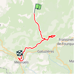

Length
21 km

Max alt
1158 m

Uphill gradient
439 m
Km-Effort
28 km

Min alt
718 m

Downhill gradient
677 m
Boucle
No
Creation date :
2019-01-15 16:41:19.208
Updated on :
2019-07-10 21:51:26.943
5h52
Difficulty : Medium

FREE GPS app for hiking
 SityTrail
IGN / Geographical institutes
SityTrail Plus
The world is yours!
About
Trail Walking of 21 km to be discovered at Occitania, Lozère, Hures-la-Parade. This trail is proposed by cron.
Positioning
Country:
France
Region :
Occitania
Department/Province :
Lozère
Municipality :
Hures-la-Parade
Location:
Unknown
Start:(Dec)
Start:(UTM)
536800 ; 4901329 (31T) N.
Comments