


Chapelle nd des Anges-Sommet Mont Ventoux

soca
User
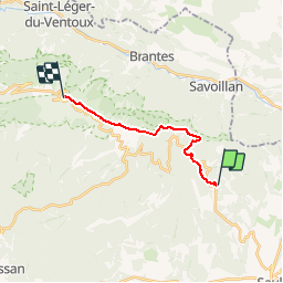

Length
12.1 km

Max alt
1889 m

Uphill gradient
968 m
Km-Effort
22 km

Min alt
1018 m

Downhill gradient
114 m
Boucle
No
Creation date :
2019-01-15 16:41:56.078
Updated on :
2019-01-15 16:41:56.078
4h57
Difficulty : Difficult

FREE GPS app for hiking
 SityTrail
IGN / Geographical institutes
SityTrail Plus
The world is yours!
About
Trail Walking of 12.1 km to be discovered at Provence-Alpes-Côte d'Azur, Vaucluse, Aurel. This trail is proposed by soca.
Positioning
Country:
France
Region :
Provence-Alpes-Côte d'Azur
Department/Province :
Vaucluse
Municipality :
Aurel
Location:
Unknown
Start:(Dec)
Start:(UTM)
690024 ; 4889666 (31T) N.
Comments