


Quélern - Roscanvel

cron
User
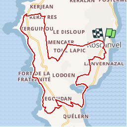

Length
11 km

Max alt
67 m

Uphill gradient
219 m
Km-Effort
14 km

Min alt
-2 m

Downhill gradient
218 m
Boucle
Yes
Creation date :
2019-01-15 16:42:14.024
Updated on :
2019-01-15 16:42:14.024
2h59
Difficulty : Easy

FREE GPS app for hiking
 SityTrail
IGN / Geographical institutes
SityTrail Plus
The world is yours!
About
Trail Walking of 11 km to be discovered at Brittany, Finistère, Roscanvel. This trail is proposed by cron.
Positioning
Country:
France
Region :
Brittany
Department/Province :
Finistère
Municipality :
Roscanvel
Location:
Unknown
Start:(Dec)
Start:(UTM)
385150 ; 5352501 (30U) N.
Comments