


bisse trien

ericf64
User
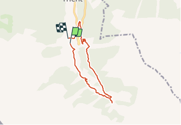

Length
6.2 km

Max alt
1650 m

Uphill gradient
340 m
Km-Effort
10.8 km

Min alt
1329 m

Downhill gradient
353 m
Boucle
Yes
Creation date :
2019-01-15 16:42:44.402
Updated on :
2019-01-15 16:42:44.402
2h05
Difficulty : Easy

FREE GPS app for hiking
 SityTrail
IGN / Geographical institutes
SityTrail Plus
The world is yours!
About
Trail Nordic walking of 6.2 km to be discovered at Valais/Wallis, Martigny, Trient. This trail is proposed by ericf64.
Description
suisse
Positioning
Country:
Switzerland
Region :
Valais/Wallis
Department/Province :
Martigny
Municipality :
Trient
Location:
Unknown
Start:(Dec)
Start:(UTM)
344855 ; 5101021 (32T) N.
Comments