


frepillon RDA 13 k

dufland
User
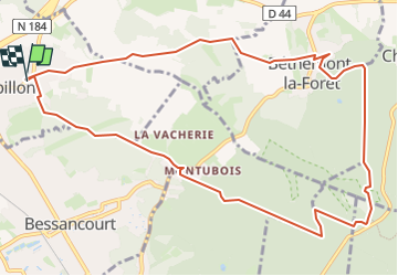

Length
11.6 km

Max alt
198 m

Uphill gradient
215 m
Km-Effort
14.4 km

Min alt
88 m

Downhill gradient
215 m
Boucle
Yes
Creation date :
2019-04-16 12:59:00.217
Updated on :
2024-03-04 16:49:53.664
--
Difficulty : Easy

FREE GPS app for hiking
 SityTrail
IGN / Geographical institutes
SityTrail Plus
The world is yours!
About
Trail Walking of 11.6 km to be discovered at Ile-de-France, Val-d'Oise, Frépillon. This trail is proposed by dufland.
Positioning
Country:
France
Region :
Ile-de-France
Department/Province :
Val-d'Oise
Municipality :
Frépillon
Location:
Unknown
Start:(Dec)
Start:(UTM)
442047 ; 5433530 (31U) N.
Comments