


croupatier de 4 auro et ses grottes

bernir
User
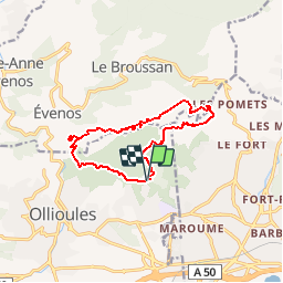

Length
12.9 km

Max alt
572 m

Uphill gradient
698 m
Km-Effort
22 km

Min alt
121 m

Downhill gradient
699 m
Boucle
Yes
Creation date :
2019-01-15 16:48:39.169
Updated on :
2019-01-15 16:48:39.169
4h30
Difficulty : Medium

FREE GPS app for hiking
 SityTrail
IGN / Geographical institutes
SityTrail Plus
The world is yours!
About
Trail Walking of 12.9 km to be discovered at Provence-Alpes-Côte d'Azur, Var, Ollioules. This trail is proposed by bernir.
Points of interest


Positioning
Country:
France
Region :
Provence-Alpes-Côte d'Azur
Department/Province :
Var
Municipality :
Ollioules
Location:
Unknown
Start:(Dec)
Start:(UTM)
733769 ; 4781196 (31T) N.
Comments