


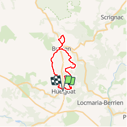
Huelgoat - Berrien

cron
User

Length
18.6 km

Max alt
265 m

Uphill gradient
342 m
Km-Effort
23 km

Min alt
142 m

Downhill gradient
342 m
Boucle
Yes
Creation date :
2019-01-15 16:52:32.543
Updated on :
2019-01-15 16:52:32.543
5h01
Difficulty : Medium

FREE GPS app for hiking
 SityTrail
IGN / Geographical institutes
SityTrail Plus
The world is yours!
About
Trail Walking of 18.6 km to be discovered at Brittany, Finistère, Huelgoat. This trail is proposed by cron.
Positioning
Country:
France
Region :
Brittany
Department/Province :
Finistère
Municipality :
Huelgoat
Location:
Unknown
Start:(Dec)
Start:(UTM)
444713 ; 5357033 (30U) N.
Comments