Trail Mountain bike Villaines-la-Carelle -  Forêt de Perseigne et Haute Sarthe - Circuit n°6  - Photo

Forêt de Perseigne et Haute Sarthe - Circuit n°6

 tracegps
tracegps

User

© OpenStreetMap contributors
Length
Length
26 km
Max alt
Max alt
352 m
Uphill gradient
Uphill gradient
555 m
Km-Effort
Km-Effort  
34 km
Min alt
Min alt
150 m
Downhill gradient
Downhill gradient
559 m
Boucle
Boucle
Yes
Creation date :
2014-12-10 00:00:00.0
Updated on :
2014-12-10 00:00:00.0

(0 Reviews)

Mountain bike
Mountain bike
2h30
Difficulty : Difficult

Scan this QR Code to open this trail in the SityTrail application

FREE GPS app for hiking

Logo SityTrail SityTrail

IGN / Geographical institutes

Download SityTrail from the App Store Download SityTrail from Google Play

Logo SityTrail SityTrail World

The world is yours!

Download SityTrail from the App Store Download SityTrail from Google Play Download SityTrail on Huawei AppGallery

About

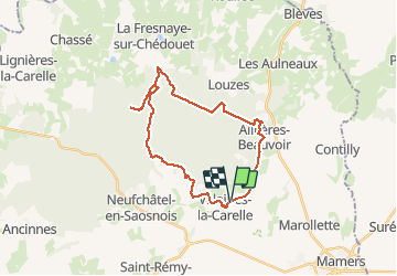
Trail Mountain bike of 26 km to be discovered at Pays de la Loire, Sarthe, Villaines-la-Carelle. This trail is proposed by tracegps.

Description

Belle boucle pour découvrir la partie Ouest du massif de Perseigne. Quelques belles montées, un portage obligatoire si on ne veut pas s'éloigner du parcours. Passage par le Belvédére de Perseigne. La boucle suit un bout du GR22. Sur la trace un petit cafouillage du à la mauvaise orientation d'une borne indicatrice.

Elevation profile

Photos

Positioning

Country:
France
Region :
Pays de la Loire
Department/Province :
Sarthe
Municipality :
Villaines-la-Carelle
Location:
Unknown
Start:(UTM)
300278 ; 5361943 (31U) N.

Trails nearby

Trail Walking Neufchâtel-en-Saosnois - Perseigne - Abbaye 8,3 km - Photo
Walking
ODDAD78

Walking

Easy
(1)
Neufchâtel-en-Saosnois, Pays de la Loire, Sarthe, France
8.4 km | 11.1 km-effort
2h 22min
Yes
Trail Walking Saint-Longis - voie verte - Photo
Walking
patmess

Walking

Very easy
(1)
Saint-Longis, Pays de la Loire, Sarthe, France
8.5 km | 10 km-effort
2h 20min
Yes
Trail Mountain bike Neufchâtel-en-Saosnois - La Laurent Brochard 2011 - Neufchatel en Saônois - Photo
Mountain bike
tracegps

Mountain bike

Medium
Neufchâtel-en-Saosnois, Pays de la Loire, Sarthe, France
35 km | 43 km-effort
2h 19min
Yes
Trail Walking Neufchâtel-en-Saosnois - Perseigne Abbaye 7,7 Km - Photo
Walking
ODDAD78

Walking

Easy
Neufchâtel-en-Saosnois, Pays de la Loire, Sarthe, France
7.7 km | 10.1 km-effort
2h 11min
Yes
Trail Walking Neufchâtel-en-Saosnois - Perseigne Abbaye 6,7 km - Photo
Walking
ODDAD78

Walking

Easy
Neufchâtel-en-Saosnois, Pays de la Loire, Sarthe, France
6.7 km | 8.6 km-effort
1h 52min
Yes
Trail Walking Villaines-la-Carelle - Perseigne 005 10,2km - Photo
Walking
ODDAD78

Walking

Medium
Villaines-la-Carelle, Pays de la Loire, Sarthe, France
10.2 km | 13.5 km-effort
2h 53min
Yes
Trail Walking Neufchâtel-en-Saosnois - Perseigne Carrefour des Trois Points - Belvédère 8,7km - Photo
Walking
ODDAD78

Walking

Easy
Neufchâtel-en-Saosnois, Pays de la Loire, Sarthe, France
8.7 km | 12.2 km-effort
2h 33min
Yes
Trail Nordic walking Louzes - belvédère Perseigne  - Photo
Nordic walking
yvesportier

Nordic walking

Difficult
Louzes, Pays de la Loire, Sarthe, France
9.7 km | 13.2 km-effort
1h 57min
Yes
Trail Walking Contilly - Contilly 8,0 Km - Photo
Walking
ODDAD78

Walking

Easy
Contilly, Pays de la Loire, Sarthe, France
8 km | 9.3 km-effort
2h 3min
Yes


Close
My subscriptions