


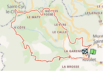
Rivolet (14 km - D. 525 m) goudron

Thomasdanielle
User

Length
14 km

Max alt
703 m

Uphill gradient
521 m
Km-Effort
21 km

Min alt
338 m

Downhill gradient
515 m
Boucle
Yes
Creation date :
2019-01-15 16:54:21.869
Updated on :
2019-01-15 16:54:21.869
4h21
Difficulty : Medium

FREE GPS app for hiking
 SityTrail
IGN / Geographical institutes
SityTrail Plus
The world is yours!
About
Trail Walking of 14 km to be discovered at Auvergne-Rhône-Alpes, Rhône, Rivolet. This trail is proposed by Thomasdanielle.
Description
Beaucoup de goudron (total 4,5 km) jeudi 27/09/18) Jean-François
Positioning
Country:
France
Region :
Auvergne-Rhône-Alpes
Department/Province :
Rhône
Municipality :
Rivolet
Location:
Unknown
Start:(Dec)
Start:(UTM)
623944 ; 5095980 (31T) N.
Comments