


j1 forez

ophness
User
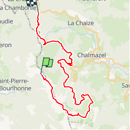

Length
32 km

Max alt
1596 m

Uphill gradient
729 m
Km-Effort
42 km

Min alt
1082 m

Downhill gradient
869 m
Boucle
No
Creation date :
2019-01-15 16:55:57.963
Updated on :
2019-01-15 16:55:57.963
--
Difficulty : Unknown

FREE GPS app for hiking
 SityTrail
IGN / Geographical institutes
SityTrail Plus
The world is yours!
About
Trail Walking of 32 km to be discovered at Auvergne-Rhône-Alpes, Puy-de-Dôme, Saint-Pierre-la-Bourlhonne. This trail is proposed by ophness.
Positioning
Country:
France
Region :
Auvergne-Rhône-Alpes
Department/Province :
Puy-de-Dôme
Municipality :
Saint-Pierre-la-Bourlhonne
Location:
Unknown
Start:(Dec)
Start:(UTM)
560931 ; 5059337 (31T) N.
Comments