Trail Mountain bike Saint-Auban - Grande Traversée des PréAlpes à VTT : St Auban - Gars - Photo

Grande Traversée des PréAlpes à VTT : St Auban - Gars

 tracegps
tracegps

User

© OpenStreetMap contributors
Length
Length
9.9 km
Max alt
Max alt
1300 m
Uphill gradient
Uphill gradient
297 m
Km-Effort
Km-Effort  
14.8 km
Min alt
Min alt
730 m
Downhill gradient
Downhill gradient
587 m
Boucle
Boucle
No
Creation date :
2014-12-10 00:00:00.0
Updated on :
2014-12-10 00:00:00.0

(2 Reviews)

Mountain bike
Mountain bike
2h00
Difficulty : Difficult

Scan this QR Code to open this trail in the SityTrail application

FREE GPS app for hiking

Logo SityTrail SityTrail

IGN / Geographical institutes

Download SityTrail from the App Store Download SityTrail from Google Play

Logo SityTrail SityTrail World

The world is yours!

Download SityTrail from the App Store Download SityTrail from Google Play Download SityTrail on Huawei AppGallery

About

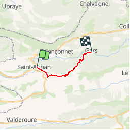
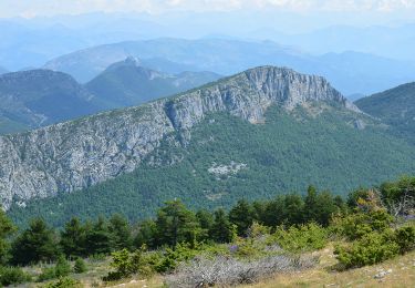
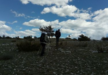
Trail Mountain bike of 9.9 km to be discovered at Provence-Alpes-Côte d'Azur, Maritime Alps, Saint-Auban. This trail is proposed by tracegps.

Description

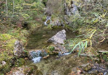
Grande Traversée des Préalpes, les Chemins du Soleil. Parcours officiel labellisé par la Fédération Française de Cyclisme. En quittant St Auban vous entrez peu à peu dans le vif du sujet sur les pentes débonnaires menant au col de Baratus. Cette petite mise en jambe de 300 mètres positifs ne doit pas relâcher votre vigilance, la dernière descente se veut un tant soit peu technique. Un petit sentier tortueux, avec quelques passages à gué, répond à nos attentes les plus joueuses, l’arrivée à Gars en n’est que trop rapide ! Consultez toutes les informations sur les hébergements et les services associés sur la fiche du tronçon.

Elevation profile

Photos

Positioning

Country:
France
Region :
Provence-Alpes-Côte d'Azur
Department/Province :
Maritime Alps
Municipality :
Saint-Auban
Location:
Unknown
Start:(UTM)
317621 ; 4857606 (32T) N.

Comments

Please log in to post a review or rate the element


Trails nearby

Trail On foot Saint-Auban - Grand tour du haut Estéron - Etape 1 - Photo
On foot
PRO

On foot

Easy
Saint-Auban, Provence-Alpes-Côte d'Azur, Maritime Alps, France
11.5 km | 17.8 km-effort
4h 3min
No
Trail Walking Saint-Auban - Le Beausset - St Auban - Clue de St Auban - Photo
Walking
LtZIP

Walking

Medium
Saint-Auban, Provence-Alpes-Côte d'Azur, Maritime Alps, France
3.7 km | 7.5 km-effort
1h 23min
Yes
Trail Walking Saint-Auban - Les Lattes - Chauvet - Pensiers Occidental et Oriental - Photo
Walking
LtZIP

Walking

Medium
Saint-Auban, Provence-Alpes-Côte d'Azur, Maritime Alps, France
11.4 km | 18.6 km-effort
3h 39min
Yes
Trail Walking Saint-Auban - Col de l'Escouissier - Photo
Walking
cswilly

Walking

Medium
Saint-Auban, Provence-Alpes-Côte d'Azur, Maritime Alps, France
9.1 km | 13.7 km-effort
2h 47min
Yes
Trail Walking Saint-Auban - Saint Auban - Photo
Walking
cswilly

Walking

Medium
Saint-Auban, Provence-Alpes-Côte d'Azur, Maritime Alps, France
17.2 km | 26 km-effort
4h 53min
Yes
Trail On foot Saint-Auban - Grand tour du haut Estéron - Photo
On foot
PRO

On foot

Very difficult
Saint-Auban, Provence-Alpes-Côte d'Azur, Maritime Alps, France
80 km | 136 km-effort
30h 57min
Yes
Trail Walking Val-de-Chalvagne - Les Cougnas Col du Buis Ubraye - Photo
Walking
Marchopier

Walking

Easy
Val-de-Chalvagne, Provence-Alpes-Côte d'Azur, Alpes-de-Haute-Provence, France
13.6 km | 21 km-effort
5h 23min
No
Trail Walking Saint-Auban - Tous les 4 à St Auban - Photo
Walking
verotrail

Walking

Difficult
Saint-Auban, Provence-Alpes-Côte d'Azur, Maritime Alps, France
10.7 km | 18.8 km-effort
6h 1min
Yes
Trail Walking Saint-Auban - Colette st auban  - Photo
Walking
adetotto

Walking

Difficult
Saint-Auban, Provence-Alpes-Côte d'Azur, Maritime Alps, France
12.3 km | 17.1 km-effort
6h 8min
Yes


Close
My subscriptions