


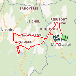
Lozere - Marchastel Le lac des salhiens 17km 190m

RandoVal
User

Length
17.1 km

Max alt
1280 m

Uphill gradient
312 m
Km-Effort
21 km

Min alt
1150 m

Downhill gradient
313 m
Boucle
Yes
Creation date :
2019-01-15 16:57:25.935
Updated on :
2019-10-12 07:32:59.659
4h36
Difficulty : Difficult

FREE GPS app for hiking
 SityTrail
IGN / Geographical institutes
SityTrail Plus
The world is yours!
About
Trail Walking of 17.1 km to be discovered at Occitania, Lozère, Marchastel. This trail is proposed by RandoVal.
Description
Circuit en Aubrac. Départ de Marchastel, parking dans la village, sens anti-horaire pour le retour par la cascade de Duroc. Pic-nic au bord du lac des Salhiens.
Positioning
Country:
France
Region :
Occitania
Department/Province :
Lozère
Municipality :
Marchastel
Location:
Unknown
Start:(Dec)
Start:(UTM)
508417 ; 4944133 (31T) N.
Comments