


MR_PLAILLY_5.3Km

GR77LP
User
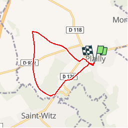

Length
5.3 km

Max alt
172 m

Uphill gradient
78 m
Km-Effort
6.3 km

Min alt
103 m

Downhill gradient
79 m
Boucle
Yes
Creation date :
2019-03-04 12:57:34.065
Updated on :
2019-03-25 13:06:11.958
1h22
Difficulty : Easy

FREE GPS app for hiking
 SityTrail
IGN / Geographical institutes
SityTrail Plus
The world is yours!
About
Trail Walking of 5.3 km to be discovered at Hauts-de-France, Oise, Plailly. This trail is proposed by GR77LP.
Description
https://www.goelerando.fr/
DAMMARTIN en GOELE 77
Photos

Positioning
Country:
France
Region :
Hauts-de-France
Department/Province :
Oise
Municipality :
Plailly
Location:
Unknown
Start:(Dec)
Start:(UTM)
469700 ; 5438964 (31U) N.
Comments
r.a.s