Trail Mountain bike Chailly-en-Brie - Espace VTT FFC - Les Coteaux du Morin et de l'Aubetin - Circuit n° 17 - Boucle1 - Photo

Espace VTT FFC - Les Coteaux du Morin et de l'Aubetin - Circuit n° 17 - Boucle1

 tracegps
tracegps

User

© OpenStreetMap contributors
Length
Length
50 km
Max alt
Max alt
168 m
Uphill gradient
Uphill gradient
509 m
Km-Effort
Km-Effort  
57 km
Min alt
Min alt
74 m
Downhill gradient
Downhill gradient
509 m
Boucle
Boucle
Yes
Creation date :
2014-12-10 00:00:00.0
Updated on :
2014-12-10 00:00:00.0

(1 Reviews)

Mountain bike
Mountain bike
4h30
Difficulty : Difficult

Scan this QR Code to open this trail in the SityTrail application

FREE GPS app for hiking

Logo SityTrail SityTrail

IGN / Geographical institutes

Download SityTrail from the App Store Download SityTrail from Google Play

Logo SityTrail SityTrail World

The world is yours!

Download SityTrail from the App Store Download SityTrail from Google Play Download SityTrail on Huawei AppGallery

About

Trail Mountain bike of 50 km to be discovered at Ile-de-France, Seine-et-Marne, Chailly-en-Brie. This trail is proposed by tracegps.

Description

Espace VTT FFC - Les Coteaux du Morin et de l'Aubetin - Circuit n° 17 - Boucle1 - Chailly en Brie - Marolles en Brie - Amillis - Dagny – Beautheuil Départ : cette boucle peut être empruntée au départ des circuits suivants : n°1 (Amillis) / n°4 (Chailly-en-Brie) / n°6 (Dagny) / n°17 (Marolles-en-Brie) Nécessite déjà une certaine endurance. Points d’accueils • Office du tourisme : 7 rue du Général de Gaulle - 77120 COULOMMIERS Tél. : 01 64 03 88 09 - mail : off.tourisme@coulommiers.fr • Vélo Nature : 8 avenue de Strasbourg - 77120 COULOMMIERS Tél. : 01 64 20 84 42 - mail : velonature@tele2.fr • Association cycliste partenaire Association Cycliste Pommeuse Boissy (ACPB) Site internet : http://acpommeuseboissy.free.fr

Elevation profile

Photos

Positioning

Country:
France
Region :
Ile-de-France
Department/Province :
Seine-et-Marne
Municipality :
Chailly-en-Brie
Location:
Unknown
Start:(UTM)
509122 ; 5404191 (31U) N.

Comments

Please log in to post a review or rate the element


Trails nearby

Trail Other activity Coulommiers - coulommiers  - Photo
Other activity
bellicaud

Other activity

Easy
(1)
Coulommiers, Ile-de-France, Seine-et-Marne, France
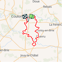
19 km | 23 km-effort
5h 0min
Yes
Trail Walking Coulommiers - COULOMMIERS > FAREMOUTIERS 18 KM - Photo
Walking
gemau77

Walking

Very easy
(1)
Coulommiers, Ile-de-France, Seine-et-Marne, France
18.2 km | 22 km-effort
4h 40min
No
Trail Walking Coulommiers - Commanderie de COULOMMIERS - Photo
Walking
pikibangi

Walking

Medium
(3)
Coulommiers, Ile-de-France, Seine-et-Marne, France
12.9 km | 15.4 km-effort
3h 9min
Yes
Trail Walking Coulommiers - Coulommiers/Aunoy - Photo
Walking
pikibangi

Walking

Very difficult
Coulommiers, Ile-de-France, Seine-et-Marne, France
23 km | 27 km-effort
5h 21min
Yes
Trail Walking Coulommiers - A l'est de Coulommiers - Photo
Walking
PatRando

Walking

Medium
Coulommiers, Ile-de-France, Seine-et-Marne, France
16.5 km | 19.1 km-effort
2h 57min
Yes
Trail Walking Coulommiers - A l'Ouest de Coulommiers  - Photo
Walking
PatRando

Walking

Easy
Coulommiers, Ile-de-France, Seine-et-Marne, France
12.8 km | 14.6 km-effort
2h 28min
Yes
Trail Walking Coulommiers - Au Sud de Coulommiers  - Photo
Walking
PatRando

Walking

Medium
Coulommiers, Ile-de-France, Seine-et-Marne, France
22 km | 24 km-effort
3h 28min
Yes
Trail Walking Coulommiers - Visite de Coulommiers  - Photo
Walking
PatRando

Walking

Very easy
Coulommiers, Ile-de-France, Seine-et-Marne, France
6.8 km | 8 km-effort
1h 41min
Yes
Trail Walking Coulommiers - Au Nord de Coulommiers  - Photo
Walking
PatRando

Walking

Easy
Coulommiers, Ile-de-France, Seine-et-Marne, France
18.1 km | 22 km-effort
3h 0min
Yes


Close
My subscriptions