


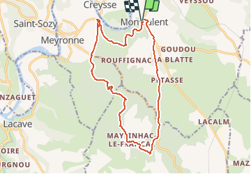
Lot - Monvalent Mayrinhac-le-Francal 17km 393m

RandoVal
User

Length
16.8 km

Max alt
285 m

Uphill gradient
422 m
Km-Effort
22 km

Min alt
104 m

Downhill gradient
422 m
Boucle
Yes
Creation date :
2019-01-15 17:07:51.861
Updated on :
2019-01-15 17:07:51.861
4h46
Difficulty : Difficult

FREE GPS app for hiking
 SityTrail
IGN / Geographical institutes
SityTrail Plus
The world is yours!
About
Trail Walking of 16.8 km to be discovered at Occitania, Lot, Montvalent. This trail is proposed by RandoVal.
Description
Boucle en Dordogne lotoise. Parking à coté de l'église, sens horaire.
Positioning
Country:
France
Region :
Occitania
Department/Province :
Lot
Municipality :
Montvalent
Location:
Unknown
Start:(Dec)
Start:(UTM)
390819 ; 4970678 (31T) N.
Comments