Trail Mountain bike Saint-Pierre-en-Auge - Randonnée VTT Le Billot du 16/05/2010 22Km - Photo

Randonnée VTT Le Billot du 16/05/2010 22Km

 tracegps
tracegps

User

© OpenStreetMap contributors
Length
Length
21 km
Max alt
Max alt
225 m
Uphill gradient
Uphill gradient
450 m
Km-Effort
Km-Effort  
27 km
Min alt
Min alt
73 m
Downhill gradient
Downhill gradient
451 m
Boucle
Boucle
Yes
Creation date :
2014-12-10 00:00:00.0
Updated on :
2014-12-10 00:00:00.0

(0 Reviews)

Mountain bike
Mountain bike
2h00
Difficulty : Difficult

Scan this QR Code to open this trail in the SityTrail application

FREE GPS app for hiking

Logo SityTrail SityTrail

IGN / Geographical institutes

Download SityTrail from the App Store Download SityTrail from Google Play

Logo SityTrail SityTrail World

The world is yours!

Download SityTrail from the App Store Download SityTrail from Google Play Download SityTrail on Huawei AppGallery

About

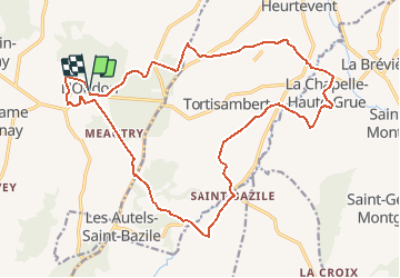
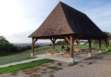
Trail Mountain bike of 21 km to be discovered at Normandy, Calvados, Saint-Pierre-en-Auge. This trail is proposed by tracegps.

Description

Départ dur des hauteurs du Billot, passage par la Foret, belle descente en terre puis remontée sur La Chapelle Haute Grue (cette partie fait le tour de Tortisambert), de nouveau une belle descente sur St Bazil mais dans la boue parfois jusqu'à mi-jante. De nouveau une montée difficile et longue mais pas infaisable, traversée des champs puis retour sur Le Billot pour terminer par leur fameuse piste de descente. Attention ça speed (50 km/h), puis remonté par la route sur le Billot. Après cela vous avez bien mérité de vous reposer ou de refaire plusieurs fois 1 des 4 pistes de descentes du Billot. (bon courage)

Elevation profile

Positioning

Country:
France
Region :
Normandy
Department/Province :
Calvados
Municipality :
Saint-Pierre-en-Auge
Location:
Unknown
Start:(UTM)
285920 ; 5427986 (31U) N.

Trails nearby

Trail Geocaching Saint-Pierre-en-Auge - Balade en campagne  - Photo
Geocaching
yannick-p

Geocaching

Easy
Saint-Pierre-en-Auge, Normandy, Calvados, France
5.4 km | 6.6 km-effort
3h 20min
Yes
Trail Walking Saint-Pierre-en-Auge - Saint Georges en Auge - Photo
Walking
Roulland

Walking

Easy
Saint-Pierre-en-Auge, Normandy, Calvados, France
16.1 km | 21 km-effort
3h 33min
Yes
Trail Walking Saint-Pierre-en-Auge - Montviette - Photo
Walking
Roulland

Walking

Easy
Saint-Pierre-en-Auge, Normandy, Calvados, France
7.1 km | 8.3 km-effort
2h 7min
Yes
Trail Walking Livarot-Pays-d'Auge -  Traditional Cache #1 Fêtons nos 2000 !!! par nounou1437 - Photo
Walking
yannick-p

Walking

Medium
Livarot-Pays-d'Auge, Normandy, Calvados, France
7 km | 8.8 km-effort
2h 0min
Yes
Trail On foot Saint-Pierre-en-Auge - Panorama sur l'Oudon - Photo
On foot
PRO

On foot

Easy
Saint-Pierre-en-Auge, Normandy, Calvados, France
12.7 km | 16.3 km-effort
3h 42min
Yes
Trail Geocaching Saint-Pierre-en-Auge - Géo-rando # 1 La petite vadrouille  - Photo
Geocaching
yannick-p

Geocaching

Medium
Saint-Pierre-en-Auge, Normandy, Calvados, France
5.4 km | 6.8 km-effort
3h 30min
Yes
Trail Walking Saint-Pierre-en-Auge - St Marguerite de Viette - Photo
Walking
Eve - Line

Walking

Easy
Saint-Pierre-en-Auge, Normandy, Calvados, France
11 km | 13.1 km-effort
2h 47min
Yes
Trail Walking Saint-Pierre-en-Auge - Monviette - Photo
Walking
Roulland

Walking

Medium
Saint-Pierre-en-Auge, Normandy, Calvados, France
22 km | 28 km-effort
5h 5min
Yes
Trail Walking Saint-Pierre-en-Auge - Vallée de l'Oudon - Photo
Walking
phi14

Walking

Easy
(1)
Saint-Pierre-en-Auge, Normandy, Calvados, France
12.9 km | 16.4 km-effort
3h 11min
Yes


Close
My subscriptions