


Boucle dans le vignoble

Claudele
User
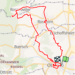

Length
24 km

Max alt
338 m

Uphill gradient
553 m
Km-Effort
31 km

Min alt
179 m

Downhill gradient
553 m
Boucle
Yes
Creation date :
2019-01-15 17:10:02.39
Updated on :
2019-01-15 17:10:02.39
7h12
Difficulty : Difficult

FREE GPS app for hiking
 SityTrail
IGN / Geographical institutes
SityTrail Plus
The world is yours!
About
Trail Walking of 24 km to be discovered at Grand Est, Bas-Rhin, Obernai. This trail is proposed by Claudele.
Positioning
Country:
France
Region :
Grand Est
Department/Province :
Bas-Rhin
Municipality :
Obernai
Location:
Unknown
Start:(Dec)
Start:(UTM)
388276 ; 5368767 (32U) N.
Comments