Trail Running Cassaniouze - pylone st projet - Photo
© OpenStreetMap contributors
Length
Length
9.8 km
Max alt
Max alt
491 m
Uphill gradient
Uphill gradient
659 m
Km-Effort
Km-Effort  
18.6 km
Min alt
Min alt
208 m
Downhill gradient
Downhill gradient
658 m
Boucle
Boucle
Yes
Creation date :
2019-01-15 17:10:14.942
Updated on :
2019-01-15 17:10:14.942

(0 Reviews)

Running
Running
1h18
Difficulty : Difficult

Scan this QR Code to open this trail in the SityTrail application

FREE GPS app for hiking

Logo SityTrail SityTrail

IGN / Geographical institutes

Download SityTrail from the App Store Download SityTrail from Google Play

Logo SityTrail SityTrail World

The world is yours!

Download SityTrail from the App Store Download SityTrail from Google Play Download SityTrail on Huawei AppGallery

About

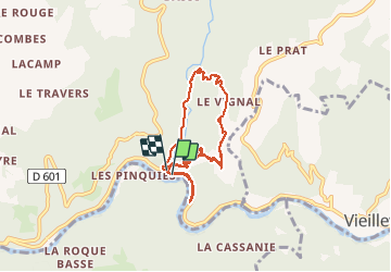
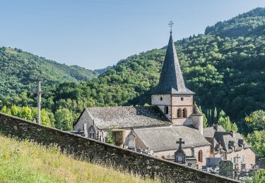
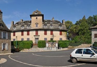
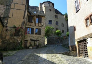
Trail Running of 9.8 km to be discovered at Auvergne-Rhône-Alpes, Cantal, Cassaniouze. This trail is proposed by kayakiste15.

Description

pylone etfin vallée de l auze

Elevation profile

Positioning

Country:
France
Region :
Auvergne-Rhône-Alpes
Department/Province :
Cantal
Municipality :
Cassaniouze
Location:
Unknown
Start:(UTM)
451346 ; 4944258 (31T) N.

Trails nearby

Trail Walking Conques-en-Rouergue - Les Pelies La Vinzelle : boucle rapide - Photo
Walking
lullaby92

Walking

Easy
(1)
Conques-en-Rouergue, Occitania, Aveyron, France
5.4 km | 8.8 km-effort
3h 19min
Yes
Trail Walking Conques-en-Rouergue - La Vinzelle - Grand Vabre - Photo
Walking
tracegps

Walking

Medium
(3)
Conques-en-Rouergue, Occitania, Aveyron, France
6.7 km | 11.1 km-effort
3h 30min
Yes
Trail On foot Conques-en-Rouergue - Terra trail 10 - Photo
On foot
PRO

On foot

Difficult
Conques-en-Rouergue, Occitania, Aveyron, France
22 km | 34 km-effort
7h 41min
Yes
Trail Walking Conques-en-Rouergue - Conques  - Photo
Walking
GUIDE
antignacs

Walking

Very easy
Conques-en-Rouergue, Occitania, Aveyron, France
10.9 km | 16.3 km-effort
3h 2min
Yes
Trail On foot Conques-en-Rouergue - Tieulet - Photo
On foot
PRO

On foot

Easy
(1)
Conques-en-Rouergue, Occitania, Aveyron, France
6.6 km | 10.5 km-effort
2h 22min
No
Trail Running Puycapel - Mourjou Châtaigne 2013  - Photo
Running
tracegps

Running

Difficult
Puycapel, Auvergne-Rhône-Alpes, Cantal, France
11.6 km | 18 km-effort
2h 0min
Yes
Trail Walking Puycapel - Mourjou Châtaigne 2013  - Photo
Walking
tracegps

Walking

Medium
Puycapel, Auvergne-Rhône-Alpes, Cantal, France
11.6 km | 18 km-effort
2h 10min
Yes
Trail Walking Conques-en-Rouergue - Sentier de Dadon - Grand Vabre - Photo
Walking
tracegps

Walking

Difficult
Conques-en-Rouergue, Occitania, Aveyron, France
19.9 km | 32 km-effort
7h 0min
Yes
Trail Walking Cassaniouze - cassaniouze st projet  - Photo
Walking
Sandrine 15

Walking

Very difficult
Cassaniouze, Auvergne-Rhône-Alpes, Cantal, France
13.6 km | 22 km-effort
2h 39min
Yes


Close
My subscriptions