


La Virée des Arlequins 2010 33km

tracegps
User
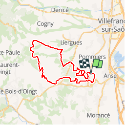

Length
29 km

Max alt
486 m

Uphill gradient
704 m
Km-Effort
38 km

Min alt
238 m

Downhill gradient
708 m
Boucle
Yes
Creation date :
2014-12-10 00:00:00.0
Updated on :
2014-12-10 00:00:00.0
3h00
Difficulty : Difficult

FREE GPS app for hiking
 SityTrail
IGN / Geographical institutes
SityTrail Plus
The world is yours!
About
Trail Mountain bike of 29 km to be discovered at Auvergne-Rhône-Alpes, Rhône, Anse. This trail is proposed by tracegps.
Description
Beau parcours bien équilibré passant par la Voie du Tacot dans le Beaujolais pour cette première édition. Accueil et organisation de bon niveau, rdv l'année prochaine!
Photos


Positioning
Country:
France
Region :
Auvergne-Rhône-Alpes
Department/Province :
Rhône
Municipality :
Anse
Location:
Unknown
Start:(Dec)
Start:(UTM)
630976 ; 5088556 (31T) N.
Comments