Trail Walking Clohars-Carnoët - De Clohars à la Roche Percée - Photo

De Clohars à la Roche Percée

 tracegps
tracegps

User

© OpenStreetMap contributors
Length
Length
9.5 km
Max alt
Max alt
60 m
Uphill gradient
Uphill gradient
104 m
Km-Effort
Km-Effort  
10.9 km
Min alt
Min alt
2 m
Downhill gradient
Downhill gradient
104 m
Boucle
Boucle
Yes
Creation date :
2014-12-10 00:00:00.0
Updated on :
2014-12-10 00:00:00.0

(1 Reviews)

Walking
Walking
2h30
Difficulty : Medium

Scan this QR Code to open this trail in the SityTrail application

FREE GPS app for hiking

Logo SityTrail SityTrail

IGN / Geographical institutes

Download SityTrail from the App Store Download SityTrail from Google Play

Logo SityTrail SityTrail World

The world is yours!

Download SityTrail from the App Store Download SityTrail from Google Play Download SityTrail on Huawei AppGallery

About

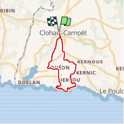
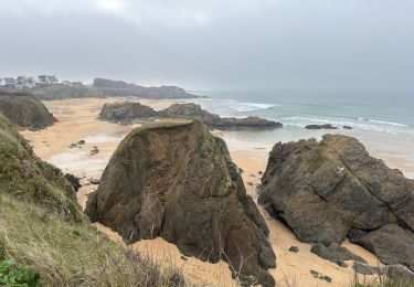
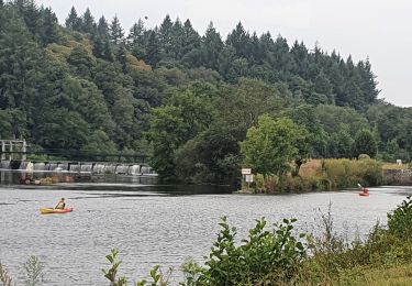
Trail Walking of 9.5 km to be discovered at Brittany, Finistère, Clohars-Carnoët. This trail is proposed by tracegps.

Description

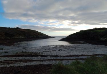
Ce circuit est balisé en bleu, cependant on vient d'ajouter des panonceaux de changement de direction jaune, de plus sur ces panonceaux il est indiqué N° 2. Le départ de ce circuit se trouve entre la pharmacie et la Poste , près de la mairie "rue de saint Jacques". Une fois arrivé à la côte, vue sur l'île de Groix.

Elevation profile

Photos

Positioning

Country:
France
Region :
Brittany
Department/Province :
Finistère
Municipality :
Clohars-Carnoët
Location:
Unknown
Start:(UTM)
456170 ; 5293761 (30T) N.

Comments

Please log in to post a review or rate the element


Trails nearby

Trail Walking Moëlan-sur-Mer - Merrien Doelan cote 11,5 km - Photo
Walking
GUIDE
rvapeldo

Walking

Medium
Moëlan-sur-Mer, Brittany, Finistère, France
12 km | 13.7 km-effort
3h 41min
No
Trail Walking Clohars-Carnoët - Le Pouldu - Photo
Walking
FOUCAULT

Walking

Clohars-Carnoët, Brittany, Finistère, France
8.1 km | 8.9 km-effort
2h 35min
Yes
Trail Walking Guidel - Guidel plage 7,6 km - Photo
Walking
GUIDE
rvapeldo

Walking

Easy
Guidel, Brittany, Morbihan, France
7.6 km | 8.5 km-effort
2h 11min
Yes
Trail Walking Clohars-Carnoët - Pouldu port peintres 6,3 km - Photo
Walking
GUIDE
rvapeldo

Walking

Easy
Clohars-Carnoët, Brittany, Finistère, France
6.3 km | 7.2 km-effort
2h 12min
Yes
Trail Walking Clohars-Carnoët - Pouldu Roche Percée et retour 9,5 km - Photo
Walking
GUIDE
rvapeldo

Walking

Medium
Clohars-Carnoët, Brittany, Finistère, France
9.5 km | 10.7 km-effort
2h 46min
Yes
Trail Walking Moëlan-sur-Mer - routoirs à lin de Pouldouran - Photo
Walking
ollivier.albert

Walking

Easy
Moëlan-sur-Mer, Brittany, Finistère, France
126 km | 155 km-effort
3h 11min
No
Trail Walking Guidel - laita - Photo
Walking
dcharbonnier

Walking

Medium
Guidel, Brittany, Morbihan, France
9.8 km | 12 km-effort
3h 58min
Yes
Trail Electric bike Clohars-Carnoët - Moelans Pontivy par les berges du Blavet - Photo
Electric bike
ilefebvre

Electric bike

Very easy
Clohars-Carnoët, Brittany, Finistère, France
81 km | 94 km-effort
4h 43min
No
Trail Walking Moëlan-sur-Mer - MOELAN Sur MER - Photo
Walking
RonanDAGORN

Walking

Medium
Moëlan-sur-Mer, Brittany, Finistère, France
10.2 km | 11.8 km-effort
3h 22min
Yes


Close
My subscriptions