
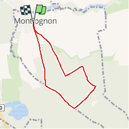
MR_MONTLOGNON(Cimetière)_6.1Km

GR77LP
User

Length
6.1 km

Max alt
98 m

Uphill gradient
52 m
Km-Effort
6.8 km

Min alt
68 m

Downhill gradient
52 m
Boucle
Yes
Creation date :
2019-03-04 12:57:29.086
Updated on :
2019-03-10 19:01:40.406
1h30
Difficulty : Easy

FREE GPS app for hiking
 SityTrail
IGN / Geographical institutes
SityTrail Plus
The world is yours!
About
Trail Walking of 6.1 km to be discovered at Hauts-de-France, Oise, Montlognon. This trail is proposed by GR77LP.
Description
https://www.goelerando.fr/
DAMMARTIN en GOËLE 77
Photos
_6.1Km - Photo 1")
Positioning
Country:
France
Region :
Hauts-de-France
Department/Province :
Oise
Municipality :
Montlognon
Location:
Unknown
Start:(Dec)
Start:(UTM)
477702 ; 5445787 (31U) N.
Comments