


Cogny (16,2 km - D. 482 m) 08-10-18

Thomasdanielle
User
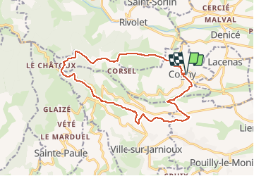

Length
16.2 km

Max alt
711 m

Uphill gradient
483 m
Km-Effort
23 km

Min alt
291 m

Downhill gradient
481 m
Boucle
Yes
Creation date :
2019-01-15 17:26:17.129
Updated on :
2019-01-15 17:26:17.129
4h46
Difficulty : Easy

FREE GPS app for hiking
 SityTrail
IGN / Geographical institutes
SityTrail Plus
The world is yours!
About
Trail Walking of 16.2 km to be discovered at Auvergne-Rhône-Alpes, Rhône, Cogny. This trail is proposed by Thomasdanielle.
Description
D/A : salle des fêtes
Organisatrice : D.Bailly
Positioning
Country:
France
Region :
Auvergne-Rhône-Alpes
Department/Province :
Rhône
Municipality :
Cogny
Location:
Unknown
Start:(Dec)
Start:(UTM)
625994 ; 5093941 (31T) N.
Comments