


samoreau vulaine

Yannick.Boireau
User

Length
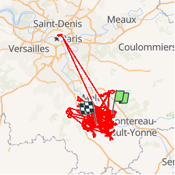
1566 km

Max alt
160 m

Uphill gradient
21757 m
Km-Effort
1857 km

Min alt
31 m

Downhill gradient
21766 m
Boucle
No
Creation date :
2019-01-15 17:32:13.578
Updated on :
2019-01-15 17:32:13.578
--
Difficulty : Unknown

FREE GPS app for hiking
 SityTrail
IGN / Geographical institutes
SityTrail Plus
The world is yours!
About
Trail Walking of 1566 km to be discovered at Ile-de-France, Seine-et-Marne, Féricy. This trail is proposed by Yannick.Boireau.
Positioning
Country:
France
Region :
Ile-de-France
Department/Province :
Seine-et-Marne
Municipality :
Féricy
Location:
Unknown
Start:(Dec)
Start:(UTM)
485228 ; 5367446 (31U) N.
Comments