


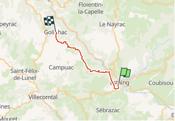
Etape09- Estaing-Golinhac

ghislainem
User

Length
14.1 km

Max alt
666 m

Uphill gradient
585 m
Km-Effort
21 km

Min alt
314 m

Downhill gradient
261 m
Boucle
No
Creation date :
2019-01-15 17:36:30.839
Updated on :
2020-08-09 07:06:02.493
4h31
Difficulty : Unknown

FREE GPS app for hiking
 SityTrail
IGN / Geographical institutes
SityTrail Plus
The world is yours!
About
Trail Walking of 14.1 km to be discovered at Occitania, Aveyron, Sébrazac. This trail is proposed by ghislainem.
Positioning
Country:
France
Region :
Occitania
Department/Province :
Aveyron
Municipality :
Sébrazac
Location:
Unknown
Start:(Dec)
Start:(UTM)
473956 ; 4933284 (31T) N.
Comments