


Etape13- Figeac-Cajarc

ghislainem
User
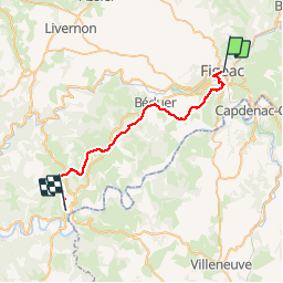

Length
32 km

Max alt
400 m

Uphill gradient
673 m
Km-Effort
41 km

Min alt
148 m

Downhill gradient
722 m
Boucle
No
Creation date :
2019-01-15 17:36:34.16
Updated on :
2019-01-15 17:36:34.16
8h41
Difficulty : Unknown

FREE GPS app for hiking
 SityTrail
IGN / Geographical institutes
SityTrail Plus
The world is yours!
About
Trail Walking of 32 km to be discovered at Occitania, Lot, Figeac. This trail is proposed by ghislainem.
Positioning
Country:
France
Region :
Occitania
Department/Province :
Lot
Municipality :
Figeac
Location:
Unknown
Start:(Dec)
Start:(UTM)
423340 ; 4939759 (31T) N.
Comments