


Etape16- Mas-de-Vers-Cahors

ghislainem
User
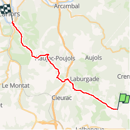

Length
18.8 km

Max alt
285 m

Uphill gradient
290 m
Km-Effort
23 km

Min alt
112 m

Downhill gradient
452 m
Boucle
No
Creation date :
2019-01-15 17:36:34.739
Updated on :
2019-01-15 17:36:34.739
4h55
Difficulty : Unknown

FREE GPS app for hiking
 SityTrail
IGN / Geographical institutes
SityTrail Plus
The world is yours!
About
Trail Walking of 18.8 km to be discovered at Occitania, Lot, Lalbenque. This trail is proposed by ghislainem.
Positioning
Country:
France
Region :
Occitania
Department/Province :
Lot
Municipality :
Lalbenque
Location:
Unknown
Start:(Dec)
Start:(UTM)
387169 ; 4912405 (31T) N.
Comments