


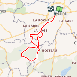
randonnée vezins 13 km

funkady
User

Length
13.6 km

Max alt
196 m

Uphill gradient
110 m
Km-Effort
15 km

Min alt
137 m

Downhill gradient
110 m
Boucle
Yes
Creation date :
2019-01-15 17:38:42.167
Updated on :
2019-01-15 17:38:42.167
2h30
Difficulty : Medium

FREE GPS app for hiking
 SityTrail
IGN / Geographical institutes
SityTrail Plus
The world is yours!
About
Trail Nordic walking of 13.6 km to be discovered at Pays de la Loire, Maine-et-Loire, Vezins. This trail is proposed by funkady.
Positioning
Country:
France
Region :
Pays de la Loire
Department/Province :
Maine-et-Loire
Municipality :
Vezins
Location:
Unknown
Start:(Dec)
Start:(UTM)
673012 ; 5220808 (30T) N.
Comments