Trail Mountain bike Malansac - Rando VTT Malansac 2010 - Photo

Rando VTT Malansac 2010

 tracegps
tracegps

User

© OpenStreetMap contributors
Length
Length
34 km
Max alt
Max alt
95 m
Uphill gradient
Uphill gradient
472 m
Km-Effort
Km-Effort  
40 km
Min alt
Min alt
26 m
Downhill gradient
Downhill gradient
472 m
Boucle
Boucle
Yes
Creation date :
2014-12-10 00:00:00.0
Updated on :
2014-12-10 00:00:00.0

(1 Reviews)

Mountain bike
Mountain bike
3h00
Difficulty : Difficult

Scan this QR Code to open this trail in the SityTrail application

FREE GPS app for hiking

Logo SityTrail SityTrail

IGN / Geographical institutes

Download SityTrail from the App Store Download SityTrail from Google Play

Logo SityTrail SityTrail World

The world is yours!

Download SityTrail from the App Store Download SityTrail from Google Play Download SityTrail on Huawei AppGallery

About

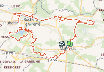
Trail Mountain bike of 34 km to be discovered at Brittany, Morbihan, Malansac. This trail is proposed by tracegps.

Description

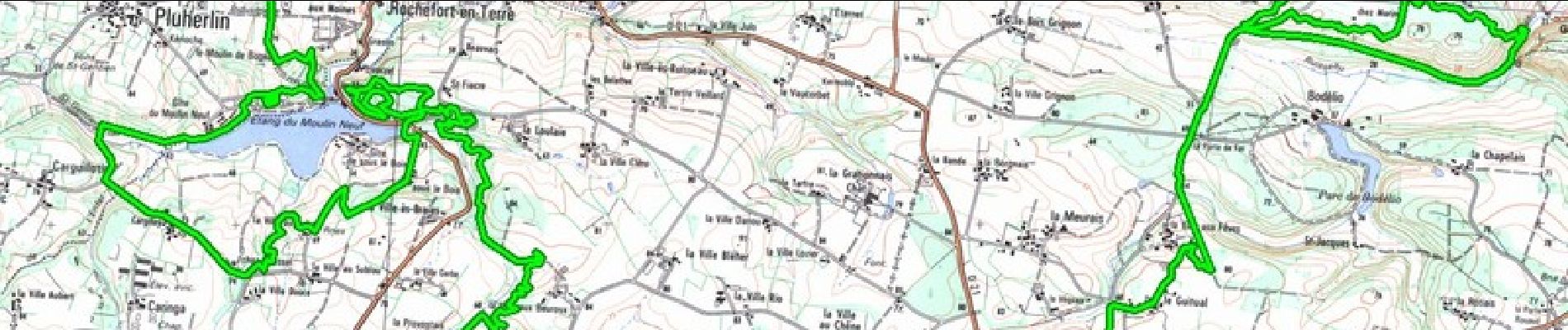
Circuit de 37 kilomètres malansac 2010 envoyé par alanri. - Découvrez les dernières vidéos de sport. Plus d'info sur www.alanric-vtt.com

Elevation profile

Photos

Positioning

Country:
France
Region :
Brittany
Department/Province :
Morbihan
Municipality :
Malansac
Location:
Unknown
Start:(UTM)
552717 ; 5280528 (30T) N.

Comments

Please log in to post a review or rate the element


Excellente application, tant sur ses fonctions que sa facilité d’utilisation. Comme toute application utilisant le gps elle est gourmande en batterie.


Trails nearby

Trail On foot Rochefort-en-Terre - Circuit de Rochefort - Photo
On foot
PRO

On foot

Easy
Rochefort-en-Terre, Brittany, Morbihan, France
7.5 km | 9.1 km-effort
2h 3min
Yes
Trail Walking Rochefort-en-Terre - Rochefort en terre - Photo
Walking
zeuhlio

Walking

Easy
(1)
Rochefort-en-Terre, Brittany, Morbihan, France
3.3 km | 4.1 km-effort
1h 25min
Yes
Trail Walking Rochefort-en-Terre - Rochefort en terre - Photo
Walking
gentyann

Walking

Easy
(1)
Rochefort-en-Terre, Brittany, Morbihan, France
14.2 km | 17.7 km-effort
3h 46min
Yes
Trail Walking Limerzel - PR_56_Limerzel_AA_01_Circuit1b_Vallee-Du-Trevelo_20231215 - Photo
Walking
patrickdanilo

Walking

Difficult
Limerzel, Brittany, Morbihan, France
11.9 km | 14 km-effort
3h 10min
Yes
Trail Walking Limerzel - GRP_Lanvaux_AI_09_Limerzel_Berric_20210528 - Photo
Walking
patrickdanilo

Walking

Easy
Limerzel, Brittany, Morbihan, France
21 km | 25 km-effort
5h 18min
No
Trail Walking Pluherlin - GRP_Lanvaux_AH_08_Rochefort-Terre_Limerzel_20210515 - Photo
Walking
patrickdanilo

Walking

Easy
Pluherlin, Brittany, Morbihan, France
13.5 km | 16.3 km-effort
3h 28min
No
Trail Walking Pluherlin - Rochefort en terre - Photo
Walking
nolsim

Walking

Medium
Pluherlin, Brittany, Morbihan, France
17.5 km | 21 km-effort
4h 1min
Yes
Trail sport Rochefort-en-Terre - 9322323-BACVTT - ASCENSION - REDON - Photo
sport
godmer

sport

Very easy
(1)
Rochefort-en-Terre, Brittany, Morbihan, France
69 km | 81 km-effort
Unknown
Yes
Trail Walking Malansac - PR_56_Malansac_AA_01_Circuit1b_Des-Ardoisieres_20160619 - Photo
Walking
patrickdanilo

Walking

Easy
Malansac, Brittany, Morbihan, France
20 km | 23 km-effort
5h 4min
Yes


Close
My subscriptions