


Le Pouldu 2

cron
User
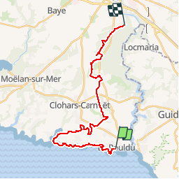

Length
26 km

Max alt
79 m

Uphill gradient
277 m
Km-Effort
29 km

Min alt
0 m

Downhill gradient
227 m
Boucle
No
Creation date :
2019-01-15 17:38:46.837
Updated on :
2019-01-15 17:38:46.837
6h27
Difficulty : Medium

FREE GPS app for hiking
 SityTrail
IGN / Geographical institutes
SityTrail Plus
The world is yours!
About
Trail Walking of 26 km to be discovered at Brittany, Finistère, Clohars-Carnoët. This trail is proposed by cron.
Positioning
Country:
France
Region :
Brittany
Department/Province :
Finistère
Municipality :
Clohars-Carnoët
Location:
Unknown
Start:(Dec)
Start:(UTM)
458970 ; 5290510 (30T) N.
Comments