


Chemin de St-Guilhem 8

cron
User
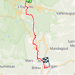

Length
19.4 km

Max alt
1314 m

Uphill gradient
297 m
Km-Effort
27 km

Min alt
237 m

Downhill gradient
1287 m
Boucle
No
Creation date :
2019-01-15 17:39:43.33
Updated on :
2019-07-10 21:53:42.385
5h14
Difficulty : Medium

FREE GPS app for hiking
 SityTrail
IGN / Geographical institutes
SityTrail Plus
The world is yours!
About
Trail Walking of 19.4 km to be discovered at Occitania, Gard, Dourbies. This trail is proposed by cron.
Positioning
Country:
France
Region :
Occitania
Department/Province :
Gard
Municipality :
Dourbies
Location:
Unknown
Start:(Dec)
Start:(UTM)
543699 ; 4882291 (31T) N.
Comments