


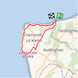
Tardinghen-Gris Nez_Audinghen

denissculier
User

Length
10.3 km

Max alt
52 m

Uphill gradient
130 m
Km-Effort
12 km

Min alt
5 m

Downhill gradient
131 m
Boucle
Yes
Creation date :
2019-01-15 17:43:13.959
Updated on :
2019-01-15 17:43:13.959
2h02
Difficulty : Medium

FREE GPS app for hiking
 SityTrail
IGN / Geographical institutes
SityTrail Plus
The world is yours!
About
Trail Nordic walking of 10.3 km to be discovered at Hauts-de-France, Pas-de-Calais, Tardinghen. This trail is proposed by denissculier.
Positioning
Country:
France
Region :
Hauts-de-France
Department/Province :
Pas-de-Calais
Municipality :
Tardinghen
Location:
Unknown
Start:(Dec)
Start:(UTM)
402703 ; 5636523 (31U) N.
Comments
Rando sympa entre les 2 caps. Certaines portion de sentier en bord de mer sont fermées car risque d'érosion. Facilement contournable par de petits détours.