Trail Walking Brosses - Mal Fontaine - Brosses - Photo

Mal Fontaine - Brosses

 tracegps
tracegps

User

© OpenStreetMap contributors
Length
Length
14.1 km
Max alt
Max alt
321 m
Uphill gradient
Uphill gradient
294 m
Km-Effort
Km-Effort  
18.1 km
Min alt
Min alt
174 m
Downhill gradient
Downhill gradient
294 m
Boucle
Boucle
Yes
Creation date :
2014-12-10 00:00:00.0
Updated on :
2014-12-10 00:00:00.0

(0 Reviews)

Walking
Walking
3h49
Difficulty : Medium

Scan this QR Code to open this trail in the SityTrail application

FREE GPS app for hiking

Logo SityTrail SityTrail

IGN / Geographical institutes

Download SityTrail from the App Store Download SityTrail from Google Play

Logo SityTrail SityTrail World

The world is yours!

Download SityTrail from the App Store Download SityTrail from Google Play Download SityTrail on Huawei AppGallery

About

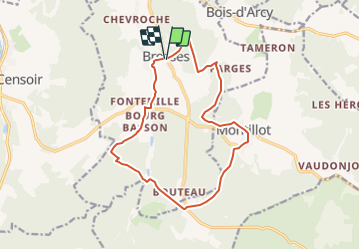
Trail Walking of 14.1 km to be discovered at Bourgogne-Franche-Comté, Yonne, Brosses. This trail is proposed by tracegps.

Description

Découverte de Brosses et ses hameaux ainsi que le village de Montillot.

Elevation profile

Positioning

Country:
France
Region :
Bourgogne-Franche-Comté
Department/Province :
Yonne
Municipality :
Brosses
Location:
Unknown
Start:(UTM)
552033 ; 5265008 (31T) N.

Trails nearby

Trail Walking Merry-sur-Yonne - BMF-140823 - Vincelles-RocherSaussois - Photo
Walking
randodan

Walking

Easy
Merry-sur-Yonne, Bourgogne-Franche-Comté, Yonne, France
14.6 km | 18.3 km-effort
4h 0min
Yes
Trail Walking Châtel-Censoir - CC n 4 - Photo
Walking
lacazen

Walking

Châtel-Censoir, Bourgogne-Franche-Comté, Yonne, France
5.1 km | 7 km-effort
2h 20min
Yes
Trail Walking Châtel-Censoir - CC N 3 - Photo
Walking
lacazen

Walking

Châtel-Censoir, Bourgogne-Franche-Comté, Yonne, France
7.4 km | 8.7 km-effort
2h 38min
Yes
Trail Walking Châtel-Censoir - CC 2023 - Photo
Walking
lacazen

Walking

Very easy
Châtel-Censoir, Bourgogne-Franche-Comté, Yonne, France
3.2 km | 4 km-effort
1h 11min
No
Trail Mountain bike Brosses - Grall VTT  - Photo
Mountain bike
monnot

Mountain bike

Easy
Brosses, Bourgogne-Franche-Comté, Yonne, France
13.6 km | 15.8 km-effort
1h 35min
Yes
Trail Walking Montillot - La Charbonnière - Photo
Walking
tracegps

Walking

Medium
(1)
Montillot, Bourgogne-Franche-Comté, Yonne, France
6.2 km | 7.2 km-effort
2h 0min
Yes
Trail Walking Brosses - De Brosses à Vaudonjon - Photo
Walking
tracegps

Walking

Medium
Brosses, Bourgogne-Franche-Comté, Yonne, France
15.3 km | 19.7 km-effort
4h 0min
Yes
Trail Walking Merry-sur-Yonne - Réserve Naturelle du Bois du Parc - Merry sur Yonne - Photo
Walking
tracegps

Walking

Medium
Merry-sur-Yonne, Bourgogne-Franche-Comté, Yonne, France
14.3 km | 17.6 km-effort
4h 0min
Yes
Trail Walking Châtel-Censoir - La Grotte aux Fées - Châtel Censoir - Photo
Walking
tracegps

Walking

Medium
Châtel-Censoir, Bourgogne-Franche-Comté, Yonne, France
11 km | 13.4 km-effort
3h 10min
Yes


Close
My subscriptions