Trail Mountain bike Fains - Randonnée à Fains 2010 - Photo

Randonnée à Fains 2010

 tracegps
tracegps

User

© OpenStreetMap contributors
Length
Length
52 km
Max alt
Max alt
155 m
Uphill gradient
Uphill gradient
749 m
Km-Effort
Km-Effort  
62 km
Min alt
Min alt
43 m
Downhill gradient
Downhill gradient
749 m
Boucle
Boucle
Yes
Creation date :
2014-12-10 00:00:00.0
Updated on :
2014-12-10 00:00:00.0

(0 Reviews)

Mountain bike
Mountain bike
3h00
Difficulty : Difficult

Scan this QR Code to open this trail in the SityTrail application

FREE GPS app for hiking

Logo SityTrail SityTrail

IGN / Geographical institutes

Download SityTrail from the App Store Download SityTrail from Google Play

Logo SityTrail SityTrail World

The world is yours!

Download SityTrail from the App Store Download SityTrail from Google Play Download SityTrail on Huawei AppGallery

About

Trail Mountain bike of 52 km to be discovered at Normandy, Eure, Fains. This trail is proposed by tracegps.

Description

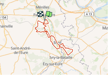
Randonnée sympathique organisée par le club de Pacy sur Eure. Parcours vallonné sans montée impossible, il est varié, champs et foret. Pour l'année prochaine, nous aurons un nouveau tracé. Tracé à faire sans vent, sinon ...il faudra mettre la tête dans le guidon. Vous aurez une vue magnifique sur les coteaux au milieu du tracé. Bonne randonnée à tous

Elevation profile

Points of interest

Point of interest Fains - Randonnée à Fains - Photo
tracegps

Positioning

Country:
France
Region :
Normandy
Department/Province :
Eure
Municipality :
Fains
Location:
Unknown
Start:(Dec)
Start:(UTM)
381781 ; 5428173 (31U) N.

Trails nearby

Trail Walking Ménilles - Ménilles - sentier de découverte - Photo
Walking
marcel.F

Walking

Easy
(2)
Ménilles, Normandy, Eure, France
10.2 km | 12.6 km-effort
2h 41min
Yes
Trail Walking Pacy-sur-Eure - Pacy-sur-Eure sur eure - Photo
Walking
JamesVautier

Walking

Easy
Pacy-sur-Eure, Normandy, Eure, France
7.9 km | 8.9 km-effort
1h 50min
Yes
Trail Walking Pacy-sur-Eure - la forét, plus plaine  - Photo
Walking
JamesVautier

Walking

Easy
Pacy-sur-Eure, Normandy, Eure, France
10.6 km | 12.2 km-effort
2h 30min
Yes
Trail Walking Pacy-sur-Eure - voie romaine depuis salle de fetes - Photo
Walking
JamesVautier

Walking

Easy
Pacy-sur-Eure, Normandy, Eure, France
10.5 km | 12 km-effort
2h 13min
Yes
Trail Walking Pacy-sur-Eure - Croissy par le haut  - Photo
Walking
JamesVautier

Walking

Easy
Pacy-sur-Eure, Normandy, Eure, France
11 km | 12.6 km-effort
2h 29min
No
Trail Walking Pacy-sur-Eure - la Voie Romaine. plus - Photo
Walking
JamesVautier

Walking

Easy
Pacy-sur-Eure, Normandy, Eure, France
10.8 km | 12.3 km-effort
2h 30min
Yes
Trail Walking Boisset-les-Prévanches - Boisset les Prévanches 2021 05 13_ - Photo
Walking
phiber76

Walking

Medium
Boisset-les-Prévanches, Normandy, Eure, France
20 km | 24 km-effort
5h 1min
Yes
Trail Road bike Pacy-sur-Eure - La vallée de l’Eure - Photo
Road bike
serleb

Road bike

Easy
Pacy-sur-Eure, Normandy, Eure, France
45 km | 50 km-effort
2h 11min
Yes
Trail Walking Pacy-sur-Eure - pacy rando 1 mars - Photo
Walking
JamesVautier

Walking

Easy
Pacy-sur-Eure, Normandy, Eure, France
7.8 km | 9.3 km-effort
2h 2min
Yes


Close
My subscriptions