


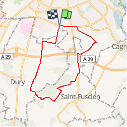
Circuit des Bois Payin et Codevelle - Amiens

tracegps
User

Length
12.3 km

Max alt
114 m

Uphill gradient
148 m
Km-Effort
14.3 km

Min alt
51 m

Downhill gradient
148 m
Boucle
Yes
Creation date :
2014-12-10 00:00:00.0
Updated on :
2014-12-10 00:00:00.0
3h04
Difficulty : Difficult

FREE GPS app for hiking
 SityTrail
IGN / Geographical institutes
SityTrail Plus
The world is yours!
About
Trail Walking of 12.3 km to be discovered at Hauts-de-France, Somme, Amiens. This trail is proposed by tracegps.
Description
Circuit proposé par la mairie de Camon . Départ du parking de la piscine Vallerey, rue Alexandre DUMAS à Amiens. Retrouvez cette randonnée sur le site de la mairie, rubrique « Tourisme et loisirs ».
Positioning
Country:
France
Region :
Hauts-de-France
Department/Province :
Somme
Municipality :
Amiens
Location:
Unknown
Start:(Dec)
Start:(UTM)
449618 ; 5524582 (31U) N.
Comments