Trail Walking Plouégat-Guérand - Sent Douron - Plouégat-Guérand - Photo

Sent Douron - Plouégat-Guérand

 tracegps
tracegps

User

© OpenStreetMap contributors
Length
Length
13.2 km
Max alt
Max alt
140 m
Uphill gradient
Uphill gradient
189 m
Km-Effort
Km-Effort  
15.7 km
Min alt
Min alt
32 m
Downhill gradient
Downhill gradient
188 m
Boucle
Boucle
Yes
Creation date :
2014-12-10 00:00:00.0
Updated on :
2014-12-10 00:00:00.0

(1 Reviews)

Walking
Walking
3h19
Difficulty : Difficult

Scan this QR Code to open this trail in the SityTrail application

FREE GPS app for hiking

Logo SityTrail SityTrail

IGN / Geographical institutes

Download SityTrail from the App Store Download SityTrail from Google Play

Logo SityTrail SityTrail World

The world is yours!

Download SityTrail from the App Store Download SityTrail from Google Play Download SityTrail on Huawei AppGallery

About

Trail Walking of 13.2 km to be discovered at Brittany, Finistère, Plouégat-Guérand. This trail is proposed by tracegps.

Description

Circuit proposé par l'Association Henchou Don Lanvaeleg. Départ de l’église de Plouégat-Guérand. Au pays des cerisiers, balade en sous bois dans le Trégor Finistérien.

Elevation profile

Photos

Positioning

Country:
France
Region :
Brittany
Department/Province :
Finistère
Municipality :
Plouégat-Guérand
Location:
Unknown
Start:(UTM)
450359 ; 5385495 (30U) N.

Comments

Please log in to post a review or rate the element


bouclé de St-Mars ch. à Lonperrier


Trails nearby

Trail Mountain bike Plestin-les-Grèves - Circuit des chapelles, coté terre - Plestin-les-Grèves - Photo
Mountain bike
tracegps

Mountain bike

Medium
(1)
Plestin-les-Grèves, Brittany, Côtes-d'Armor, France
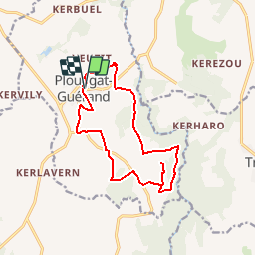
17.1 km | 20 km-effort
2h 0min
Yes
Trail Walking Plestin-les-Grèves - Circuit de la chapelle Sainte Anne - Plestin-les-Grèves - Photo
Walking
tracegps

Walking

Easy
Plestin-les-Grèves, Brittany, Côtes-d'Armor, France
6.9 km | 8.4 km-effort
1h 40min
Yes
Trail Walking Plestin-les-Grèves - Circuit de la chapelle St Jagut - Plestin-les-Grèves - Photo
Walking
tracegps

Walking

Easy
Plestin-les-Grèves, Brittany, Côtes-d'Armor, France
7.9 km | 9.2 km-effort
2h 0min
Yes
Trail Mountain bike Plestin-les-Grèves - Circuit des chapelles, coté mer - Plestin-les-Grèves - Photo
Mountain bike
tracegps

Mountain bike

Easy
Plestin-les-Grèves, Brittany, Côtes-d'Armor, France
9.6 km | 11.2 km-effort
1h 0min
Yes
Trail On foot Plestin-les-Grèves - GR 34 B - Photo
On foot
PRO

On foot

Easy
Plestin-les-Grèves, Brittany, Côtes-d'Armor, France
3.6 km | 4.2 km-effort
57min
No
Trail Walking Plestin-les-Grèves - Circuit de la chapelle St Roch - Plestin-les-Grèves - Photo
Walking
tracegps

Walking

Easy
Plestin-les-Grèves, Brittany, Côtes-d'Armor, France
5.8 km | 7.2 km-effort
1h 30min
Yes
Trail Walking Plouégat-Guérand - Plouegat Guerrand - Photo
Walking
0658294C

Walking

Difficult
Plouégat-Guérand, Brittany, Finistère, France
10.4 km | 12.5 km-effort
2h 52min
Yes
Trail Other activity Plestin-les-Grèves - Douron - Photo
Other activity
filite

Other activity

Very easy
Plestin-les-Grèves, Brittany, Côtes-d'Armor, France
12.6 km | 14.8 km-effort
4h 40min
Yes
Trail Walking Lanmeur - Le petit train - Photo
Walking
jh.daniel

Walking

Easy
Lanmeur, Brittany, Finistère, France
9.3 km | 10.4 km-effort
2h 17min
Yes


Close
My subscriptions