Trail Walking Mittelbergheim - Mittelbergheim - Château du Landsberg - Photo

Mittelbergheim - Château du Landsberg

 tracegps
tracegps

User

© OpenStreetMap contributors
Length
Length
15.4 km
Max alt
Max alt
587 m
Uphill gradient
Uphill gradient
569 m
Km-Effort
Km-Effort  
23 km
Min alt
Min alt
212 m
Downhill gradient
Downhill gradient
568 m
Boucle
Boucle
Yes
Creation date :
2014-12-10 00:00:00.0
Updated on :
2014-12-10 00:00:00.0

(3 Reviews)

Walking
Walking
5h00
Difficulty : Medium

Scan this QR Code to open this trail in the SityTrail application

FREE GPS app for hiking

Logo SityTrail SityTrail

IGN / Geographical institutes

Download SityTrail from the App Store Download SityTrail from Google Play

Logo SityTrail SityTrail World

The world is yours!

Download SityTrail from the App Store Download SityTrail from Google Play Download SityTrail on Huawei AppGallery

About

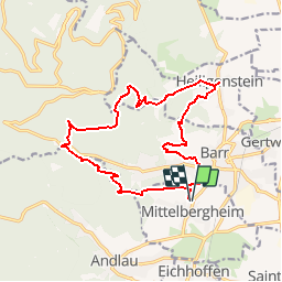
Trail Walking of 15.4 km to be discovered at Grand Est, Bas-Rhin, Mittelbergheim. This trail is proposed by tracegps.

Description

e château du Lansberg est situé sur le ban de la commune de Heiligenstein, dans le Bas-Rhin. Il fait l'objet d'un classement au titre des monuments historiques[2] depuis octobre 1965. Le château est construit au début du XIIIe siècle par Conrad de Landsberg pour assurer la défense des abbayes du Mont Sainte-Odile, de Niedermunster, de Truttenhausen et d'Andlau.

Elevation profile

Points of interest

Point of interest Barr - Caf? - Photo
tracegps
BARR 
Point of interest Heiligenstein - Resto - Photo
tracegps
HEILIGENSTEIN 

Positioning

Country:
France
Region :
Grand Est
Department/Province :
Bas-Rhin
Municipality :
Mittelbergheim
Location:
Unknown
Start:(UTM)
384705 ; 5361814 (32U) N.

Comments

Please log in to post a review or rate the element


parfait


Très sympa, parcours géologique, vignoble, forêt ruine du château, nécessite une petite condition physique...à faire


Trails nearby

Trail Walking Ottrott - Le circuit sud du Mur Païen - Photo
Walking
VacheKiri67

Walking

Easy
(2)
Ottrott, Grand Est, Bas-Rhin, France
4.9 km | 6.3 km-effort
1h 56min
No
Trail Walking Ottrott - Le circuit nord du Mur Païen - Photo
Walking
VacheKiri67

Walking

Easy
(1)
Ottrott, Grand Est, Bas-Rhin, France
5.9 km | 8.5 km-effort
2h 4min
No
Trail Walking Andlau - Depuis Andlau vers le village viticole de Mittelbergheim - Photo
Walking
VacheKiri67

Walking

Medium
(1)
Andlau, Grand Est, Bas-Rhin, France
11.9 km | 15.9 km-effort
4h 3min
Yes
Trail Walking Ottrott - Le mur païen - Photo
Walking
VacheKiri67

Walking

Medium
(4)
Ottrott, Grand Est, Bas-Rhin, France
10.5 km | 14.5 km-effort
4h 36min
Yes
Trail Walking Ottrott - Mur Paien complet - Photo
Walking
markrei

Walking

Medium
(1)
Ottrott, Grand Est, Bas-Rhin, France
12 km | 16.4 km-effort
5h 25min
Yes
Trail Mountain bike Barr - Circuit des 3 Petits Ponts - Photo
Mountain bike
tracegps

Mountain bike

Difficult
(1)
Barr, Grand Est, Bas-Rhin, France
15.9 km | 22 km-effort
1h 19min
Yes
Trail Horseback riding Epfig - 2022-11-11 Journee Epfig Nothalten Dambach - Photo
Horseback riding
GUIDE
holtzv

Horseback riding

Medium
Epfig, Grand Est, Bas-Rhin, France
22 km | 27 km-effort
3h 48min
Yes
Trail Walking Reichsfeld - 2019-12-28 Marche Reichsfeld Ungersberg Gruckert - Photo
Walking
GUIDE
holtzv

Walking

Very easy
Reichsfeld, Grand Est, Bas-Rhin, France
12.2 km | 20 km-effort
3h 5min
Yes
Trail Walking Nothalten - nothalten - Photo
Walking
rensmusic

Walking

Very easy
(1)
Nothalten, Grand Est, Bas-Rhin, France
9.6 km | 13 km-effort
2h 13min
No


Close
My subscriptions