


resto libre st bernard plan 1

ophness
User
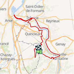

Length
35 km

Max alt
272 m

Uphill gradient
309 m
Km-Effort
40 km

Min alt
163 m

Downhill gradient
312 m
Boucle
No
Creation date :
2019-01-15 17:55:23.028
Updated on :
2019-01-15 17:55:23.028
4h16
Difficulty : Unknown

FREE GPS app for hiking
 SityTrail
IGN / Geographical institutes
SityTrail Plus
The world is yours!
About
Trail Winter sports of 35 km to be discovered at Auvergne-Rhône-Alpes, Rhône, Chasselay. This trail is proposed by ophness.
Positioning
Country:
France
Region :
Auvergne-Rhône-Alpes
Department/Province :
Rhône
Municipality :
Chasselay
Location:
Unknown
Start:(Dec)
Start:(UTM)
638183 ; 5081646 (31T) N.
Comments