


45 km dans les Puys - Chamalières

tracegps
User
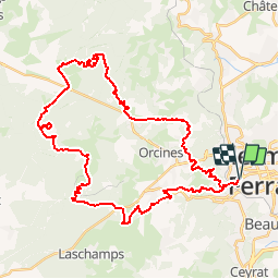

Length
45 km

Max alt
1418 m

Uphill gradient
1943 m
Km-Effort
71 km

Min alt
424 m

Downhill gradient
1943 m
Boucle
Yes
Creation date :
2014-12-10 00:00:00.0
Updated on :
2014-12-10 00:00:00.0
10h00
Difficulty : Difficult

FREE GPS app for hiking
 SityTrail
IGN / Geographical institutes
SityTrail Plus
The world is yours!
About
Trail Walking of 45 km to be discovered at Auvergne-Rhône-Alpes, Puy-de-Dôme, Chamalières. This trail is proposed by tracegps.
Description
Description à suivre.


Positioning
Country:
France
Region :
Auvergne-Rhône-Alpes
Department/Province :
Puy-de-Dôme
Municipality :
Chamalières
Location:
Unknown
Start:(Dec)
Start:(UTM)
504788 ; 5068899 (31T) N.
Comments