


20181024 Tavernes Rando réelle.

Sugg
User
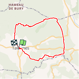

Length
17.2 km

Max alt
689 m

Uphill gradient
460 m
Km-Effort
23 km

Min alt
351 m

Downhill gradient
458 m
Boucle
Yes
Creation date :
2019-03-22 16:57:41.036
Updated on :
2019-03-22 16:57:41.149
6h26
Difficulty : Medium

FREE GPS app for hiking
 SityTrail
IGN / Geographical institutes
SityTrail Plus
The world is yours!
About
Trail Walking of 17.2 km to be discovered at Provence-Alpes-Côte d'Azur, Var, Tavernes. This trail is proposed by Sugg.
Description
les 3 croix, la chapelle Notre Dame de Bellevue.
Photos


Positioning
Country:
France
Region :
Provence-Alpes-Côte d'Azur
Department/Province :
Var
Municipality :
Tavernes
Location:
Unknown
Start:(Dec)
Start:(UTM)
258984 ; 4830961 (32T) N.
Comments