


Roc de Nant

ARVIEU
User
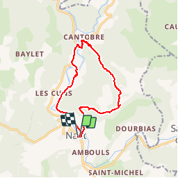

Length
13.3 km

Max alt
861 m

Uphill gradient
533 m
Km-Effort
20 km

Min alt
453 m

Downhill gradient
530 m
Boucle
Yes
Creation date :
2019-01-15 18:00:04.56
Updated on :
2019-01-15 18:00:04.56
4h14
Difficulty : Medium

FREE GPS app for hiking
 SityTrail
IGN / Geographical institutes
SityTrail Plus
The world is yours!
About
Trail Walking of 13.3 km to be discovered at Occitania, Aveyron, Nant. This trail is proposed by ARVIEU.
Positioning
Country:
France
Region :
Occitania
Department/Province :
Aveyron
Municipality :
Nant
Location:
Unknown
Start:(Dec)
Start:(UTM)
524318 ; 4874363 (31T) N.
Comments