


20/01/2018 - AMANLIS nord et sud.Virtuel

chasle
User

Length
19.4 km

Max alt
86 m

Uphill gradient
213 m
Km-Effort
22 km

Min alt
28 m

Downhill gradient
213 m
Boucle
Yes
Creation date :
2019-01-15 18:00:38.407
Updated on :
2019-01-15 18:00:38.407
4h51
Difficulty : Medium

FREE GPS app for hiking
 SityTrail
IGN / Geographical institutes
SityTrail Plus
The world is yours!
About
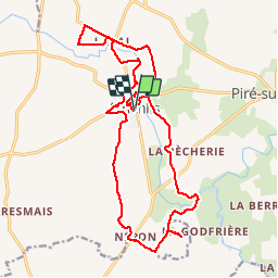
Trail Walking of 19.4 km to be discovered at Brittany, Ille-et-Vilaine, Amanlis. This trail is proposed by chasle.
Positioning
Country:
France
Region :
Brittany
Department/Province :
Ille-et-Vilaine
Municipality :
Amanlis
Location:
Unknown
Start:(Dec)
Start:(UTM)
613680 ; 5318039 (30U) N.
Comments