


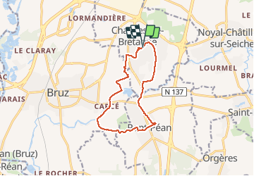
30.10.2018 - CHARTRES À PONT PÉAN

babeth35
User

Length
11.4 km

Max alt
41 m

Uphill gradient
64 m
Km-Effort
12.3 km

Min alt
16 m

Downhill gradient
65 m
Boucle
Yes
Creation date :
2019-01-15 18:09:38.699
Updated on :
2020-07-20 15:01:56.774
2h45
Difficulty : Very easy

FREE GPS app for hiking
 SityTrail
IGN / Geographical institutes
SityTrail Plus
The world is yours!
About
Trail Walking of 11.4 km to be discovered at Brittany, Ille-et-Vilaine, Chartres-de-Bretagne. This trail is proposed by babeth35.
Positioning
Country:
France
Region :
Brittany
Department/Province :
Ille-et-Vilaine
Municipality :
Chartres-de-Bretagne
Location:
Unknown
Start:(Dec)
Start:(UTM)
596472 ; 5321464 (30U) N.
Comments