Trail Mountain bike Betchat - Espace VTT FFC Couserans-Volvestre en Pyrénées - Sentier de Bonrepaux n°14 - Photo

Espace VTT FFC Couserans-Volvestre en Pyrénées - Sentier de Bonrepaux n°14

 tracegps
tracegps

User

© OpenStreetMap contributors
Length
Length
15.8 km
Max alt
Max alt
486 m
Uphill gradient
Uphill gradient
411 m
Km-Effort
Km-Effort  
21 km
Min alt
Min alt
332 m
Downhill gradient
Downhill gradient
412 m
Boucle
Boucle
Yes
Creation date :
2014-12-10 00:00:00.0
Updated on :
2014-12-10 00:00:00.0

(0 Reviews)

Mountain bike
Mountain bike
1h30
Difficulty : Difficult

Scan this QR Code to open this trail in the SityTrail application

FREE GPS app for hiking

Logo SityTrail SityTrail

IGN / Geographical institutes

Download SityTrail from the App Store Download SityTrail from Google Play

Logo SityTrail SityTrail World

The world is yours!

Download SityTrail from the App Store Download SityTrail from Google Play Download SityTrail on Huawei AppGallery

About

Trail Mountain bike of 15.8 km to be discovered at Occitania, Ariège, Betchat. This trail is proposed by tracegps.

Description

Espace VTT FFC Couserans-Volvestre en Pyrénées - Sentier de Bonrepaux n°14 Départ de l’aire d’accueil à la forêt de Betchat. Circuit officiel labellisé par la Fédération Française de Cyclisme. Vous partirez du coeur de la forêt de Betchat et profiterez de sa belle ambiance pour rejoindre la vallée du Salat et le village de Lacave. Après une éventuelle halte dans le parc aux arbres centenaires (cèdres, tulipier de Virginie…), vous fournirez un dernier effort pour remonter vers le bois de Terre-Rouge et boucler ce beau parcours. Renseignements ; • Office de Tourisme Volvestre Couserans Place de l’Espy 09230 SAINTE-CROIX VOLVESTRE - Tél. 05 61 04 60 55 // Fax 05 61 66 27 98 - ot.volvestre.ariegeois (at) wanadoo.fr • Office de Tourisme de Saint-Lizier - Place Notre dame 09190 SAINT-LIZIER - Tél. 05 61 96 77 77 - ot.saintlizier (at) wanadoo.fr

Elevation profile

Photos

Positioning

Country:
France
Region :
Occitania
Department/Province :
Ariège
Municipality :
Betchat
Location:
Unknown
Start:(UTM)
340047 ; 4770109 (31T) N.

Trails nearby

Trail Mountain bike Caumont - Espace VTT FFC Couserans-Volvestre en Pyrénées - Sentier de Gèle n°20 - Photo
Mountain bike
tracegps

Mountain bike

Very difficult
Caumont, Occitania, Ariège, France
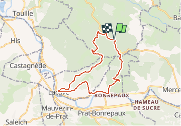
17.1 km | 22 km-effort
1h 45min
Yes
Trail Walking La Bastide-du-Salat - dessus de la bastide de salat - Photo
Walking
kayamambo

Walking

Difficult
La Bastide-du-Salat, Occitania, Ariège, France
8.1 km | 10.5 km-effort
2h 39min
Yes
Trail Mountain bike Betchat - Espace VTT FFC Couserans-Volvestre en Pyrénées - Sentier d'Isère et Crabasse n°13 - Photo
Mountain bike
tracegps

Mountain bike

Medium
Betchat, Occitania, Ariège, France
12.9 km | 17 km-effort
1h 0min
Yes
Trail Mountain bike Betchat - Espace VTT FFC Couserans-Volvestre en Pyrénées - Sentier de Soulagnet n°12 - Photo
Mountain bike
tracegps

Mountain bike

Difficult
Betchat, Occitania, Ariège, France
15.5 km | 21 km-effort
1h 0min
Yes
Trail Mountain bike Bagert - Espace VTT FFC Couserans-Volvestre en Pyrénées - Sentier de Bergès n°10 - Photo
Mountain bike
tracegps

Mountain bike

Difficult
Bagert, Occitania, Ariège, France
6.5 km | 10 km-effort
40min
Yes
Trail Hybrid bike Prat-Bonrepaux - vélo lacave - Photo
Hybrid bike
kayamambo

Hybrid bike

Medium
Prat-Bonrepaux, Occitania, Ariège, France
31 km | 34 km-effort
2h 17min
Yes
Trail Walking Prat-Bonrepaux - Prat Bonrepaux  - Photo
Walking
Fafou64

Walking

Medium
Prat-Bonrepaux, Occitania, Ariège, France
19.2 km | 25 km-effort
4h 14min
Yes
Trail Running Saleich - TRAIL-Saleich 33 - Photo
Running
Polo-31

Running

Medium
Saleich, Occitania, Haute-Garonne, France
32 km | 50 km-effort
6h 0min
Yes
Trail Running Saleich - TRAIL-Saleich 22 - Photo
Running
Polo-31

Running

Medium
Saleich, Occitania, Haute-Garonne, France
21 km | 32 km-effort
3h 10min
Yes


Close
My subscriptions