Trail Walking Bozouls - De Barriac à Rodelle - Photo

De Barriac à Rodelle

 tracegps
tracegps

User

© OpenStreetMap contributors
Length
Length
12.3 km
Max alt
Max alt
598 m
Uphill gradient
Uphill gradient
314 m
Km-Effort
Km-Effort  
16.5 km
Min alt
Min alt
359 m
Downhill gradient
Downhill gradient
312 m
Boucle
Boucle
Yes
Creation date :
2014-12-10 00:00:00.0
Updated on :
2014-12-10 00:00:00.0

(0 Reviews)

Walking
Walking
3h15
Difficulty : Medium

Scan this QR Code to open this trail in the SityTrail application

FREE GPS app for hiking

Logo SityTrail SityTrail

IGN / Geographical institutes

Download SityTrail from the App Store Download SityTrail from Google Play

Logo SityTrail SityTrail World

The world is yours!

Download SityTrail from the App Store Download SityTrail from Google Play Download SityTrail on Huawei AppGallery

About

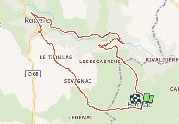
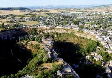
Trail Walking of 12.3 km to be discovered at Occitania, Aveyron, Bozouls. This trail is proposed by tracegps.

Description

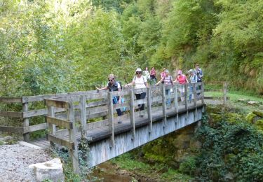
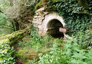
Pour cette jolie promenade, le départ se fait normalement à Barriac. Vous pouvez vous garer à côté de l'église ou mieux prenez la rue qui part en face de la porte de l'église sur 100 m et la rue en voie sans issue où il y a beaucoup plus d'espace pour se garer. Deuxième départ possible,Rodelle. Vous avez un grand parking à l'entrée du village, Rodelle qui est un site classé, joli village à visiter. Vous avez aussi a 1 km du parking en prenant la direction de Villecomtal la grotte de Sainte Tarcisse lieu de culte. En ce qui concerne la randonnée, elle ne présente aucune difficulté, balisée en jaune, très agréable je la fais tous les ans. Quant à la durée ? Tout seul en prenant mon temps je mets environ 2:45 minutes sur le topo guide il la donne en 4:30!!!! Je pense qu'ils doivent s'arrêter à l'auberge à Rodelle pour casser la croûte !!! Bonne balade à tous.

Elevation profile

Photos

Positioning

Country:
France
Region :
Occitania
Department/Province :
Aveyron
Municipality :
Bozouls
Location:
Unknown
Start:(UTM)
473157 ; 4923980 (31T) N.

Trails nearby

Trail On foot Sébazac-Concourès - Circuit 17 Concourès - Photo
On foot
PRO

On foot

Easy
Sébazac-Concourès, Occitania, Aveyron, France
9 km | 10.6 km-effort
2h 24min
Yes
Trail Walking Rodelle - BEZONNES Nord - Photo
Walking
Strabidja

Walking

Medium
(1)
Rodelle, Occitania, Aveyron, France
6 km | 6.3 km-effort
1h 25min
Yes
Trail Walking Bozouls - Trou de Bozouls - Photo
Walking
jmpu

Walking

Easy
(4)
Bozouls, Occitania, Aveyron, France
14.5 km | 19.9 km-effort
4h 15min
Yes
Trail Mountain bike Rodelle - Ledenac 2 - Photo
Mountain bike
bonnetchristian

Mountain bike

Very easy
(1)
Rodelle, Occitania, Aveyron, France
5.5 km | 6.8 km-effort
Unknown
No
Trail On foot Bozouls - De Bozouls à Rodelle - Photo
On foot
PRO

On foot

Easy
Bozouls, Occitania, Aveyron, France
10.4 km | 13.6 km-effort
3h 4min
No
Trail Walking Bozouls - Bozoul (Après-midi) - Photo
Walking
jesusmarieclaire

Walking

Easy
Bozouls, Occitania, Aveyron, France
4.8 km | 6.6 km-effort
2h 0min
Yes
Trail On foot Bozouls - BARRIAC / CARCUAC - Photo
On foot
Strabidja

On foot

Easy
Bozouls, Occitania, Aveyron, France
3.9 km | 4.8 km-effort
1h 0min
Yes
Trail Walking Bozouls - Le site géologique de Bozouls - Photo
Walking
GUIDE
jagarnier

Walking

Medium
(1)
Bozouls, Occitania, Aveyron, France
15.7 km | 21 km-effort
4h 45min
Yes
Trail Walking Bozouls - Circuit des passerelles à Bozouls - Photo
Walking
GUIDE
jagarnier

Walking

Medium
Bozouls, Occitania, Aveyron, France
11.6 km | 16.3 km-effort
3h 30min
Yes


Close
My subscriptions