


Col des Marous par les Col Legrillou et Uscla

tracegps
User


2h00
Difficulty : Difficult

FREE GPS app for hiking
 SityTrail
IGN / Geographical institutes
SityTrail Plus
The world is yours!
About
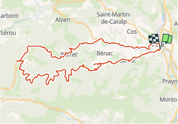
Trail Cycle of 55 km to be discovered at Occitania, Ariège, Foix. This trail is proposed by tracegps.
Description
Circuit agréable, difficulté moyenne jusqu'au col Legrillou, puis plat montant en milieu forestier, très agréable par temps chaud. En redescendant sur Foix on peut au col des Marous redescendre par la Bastide de Sérou et revenir par Alzun. Prévoir une bonne heure de plus.
Positioning
Comments